|
MyCen Directions: Taman Tun Dr Ismail - TTDI
|
Driving guide & ground directions with road maps, street pictures & information of the route, location or area
|
| Find Other Places: Directions & Map Index | Search For A Location | More Maps Here |
|
|
 MyCen Directions
Updated & Current
Clear & Accurate Maps
With Latest Landmarks
GPS Verified On Ground
Portal-Wide Useful Links
Picture Of Every Location
Comprehensive Information
Made With Local Knowledge
Each Place Visited In Person
Satellite & Google Earth View
Independent Opinion & Review

As Seen On TV's

|
Taman Tun Dr Ismail, Kuala Lumpur
|
|
|
|
If interactive map above is slow to load or not showing, CLICK HERE for static view
|
|
|
|
|
| View the Full MyCen Events Calendar here |
|
Address: Kuala Lumpur, Malaysia
Postcode (Poskod): 60000 Kuala Lumpur
Tel:
Fax:
Website: http://www.nazattdi.com/ (developer)
Area: Wilayah Persekutuan Kuala Lumpur, Federal Territory of Kuala Lumpur (KL / WP)
Jurisdiction: Dewan Bandaraya Kuala Lumpur DBKL - KL City Hall (See Local Govt)
Directions: Taman Tun Dr Ismail can be accessed by the LDP and the Penchala Link from Mont Kiara.
Info / Insights: Taman Tun Dr Ismail was one of the earliest satellite townships off Kuala Lumpur. It was named after the former Deputy Prime Minister, Tun Dr Ismail Abdul Rahman. The housing estate is often referred to as TTDI or Taman Tun.
Built in the early 1970s, its location was then considered too remote. The once winding and narrow Damansara road was mostly used by lorries heading to and from the Bukit Lanjan stone quarries. Today, the surrounding rubber plantations to its north and west have turned into gold mines. With incessant growth in the area, every remaining inch of land is sought for property development.
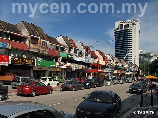
To its credit, nothing major has changed in TTDI for the last four decades. It remained the peaceful, spacious and well-planned residential enclave it was originally envisioned. Except for the new Plaza TTDI and a couple of new condos, time seems to have come to a standstill somewhat.
The town is flanked by two commercial centres. The southern one is where the Jusco Store and West Point Club once stood. The landmark skyscraper there has undergone several iterations from TTDI Plaza to IBM Plaza to the current VADS Plaza. The new TTDI Plaza commercial complex and condominium towers are at the back, near the indoor market.
The northern commercial centre too, has seen its ups and downs with several new pubs and bistros currently drawing outsiders to the area. The popular Rasta joint has moved to the back, near the Kampung Sg Penchala interchange.
Surprising as it may be, there is plenty of (remaining) greenery at its doorstep. The idyllic and rustic Sungei Penchala village is just at the back and the accessible Bukit Kiara forest runs parallel.
The original developer TTDI Development is now known as Naza TTDI.
Links: Taman Tun Dr Ismail Residents Association (http://ttdi-ra.com.my/)
Nearby Landmarks: Pusat Komuniti Taman Tun Dr Ismail, Dewan Serbaguna TTDI & Perpustakaan (1), Balai Polis Taman Tun Dr Ismail (2), Masjid Al-Taqwa Mosque (3)
Surrounding Places: Badan Kebajikan Islam Taman Tun Dr Ismail - Bakti-TTDI (4), Tadika Diyana (5), Pusat Injil TTDI - TTDI Gospel Centre (6), Pinggiran Kiara Condo (7), Kiara View Condo (8), TTDI Hills Gated Homes (9), Mas Kiara Condo (10), Restoran Puteri (11), Rasta TTDI Food Court (12), Kiara Park Condo (13), Sri TTDI Condo (14), Villa Flora Condo (15), Restoran Muhibbah (16), Sid's Pub (17), Graphics Vision (18), Apollo TTDI Medical Centre (19), The Reef Pub (20), Applied Imaging (21), Kuarters Institusi Pendidikan Apartments (22), Ibusawat TM Taman Tun Dr Ismail - Telekom Exchange TTDI (23),
Subway, KFC & Petronas (24), Pejabat Cawangan RapidKL TTDI Branch (25), Bangunan AHP - Mantissa College Block A (27), Balai Bomba & Penyelamat Taman Tun Dr Ismail (28), Tapak Pasar Malam - Night Market Site On Sundays Afternoons & Nights Only (29), Tapak Bazar Ramadan TTDI - Ramadhan Bazaar Site (Fasting Month Only) (30), Slegehammer Communications (31), Klinik Ibu-Ibu Mengandung & Kanak Kanak (32), Trellises Condo (33), Kiara Green Townhouses (34), Plaza VADS (35), DBKL Pejabat Cawangan Segambut (36), Celcom Branch (39), Maxis Centre TTDI (40), Pasar Besar (Moden) Taman Tun Dr Ismail Market (41), TTDI Plaza & Naza World & (42), Brunsfield Centre (43), The Plaza Condo (44), The Residence Condo (45),
Taman Rimba Kiara - Recreation Park (46), TTDI Longhouses (47), Bangunan Bakti Siti Hasmah (48), Wisma WIM - Womens' Institute of Management (Institut Pengurusan Wanita) & Mantissa College Block C (49), Entrance To Taman Lembah Kiara (50), Car Park For Taman Tasik Lembah Kiara (51), Back Exit & Entrance To Kuala Lumpur Golf & Country Club KLGCC (52), Damansara Specialist Hospital DSH - Hsopital Pakar Damansara (53), Damansara Kim (54), Uptown Damansara, Damansara Utama (55), To 1 Utama, Bandar Utama (56), To Mutiara Damansara, Damansara Perdana & Kepong (57), To Penchala Tunnel (Link) & Mont Kiara (58), To Kampung Sungai Penchala (59)
Surrounding Roads & Areas: Jalan Leong Yew Koh, Jalan Tun Mohd Fuad, Pinggiran Zaaba, Jalan Wan Kadir, Jalan Abang Haji Openg, Jalan Athinahapan, Jalan Burhanuddin Helmi, Jalan Aminuddin Baki, Lorong Rahim Kajai 14, Jalan Datuk Sulaiman, Jalan SS20/10, Lebuhraya Damansara-Puchong LDP, Jalan Sungei Penchala, Penchala Link (Sprint) Seksyen SS20 (Damansara Kim), SS21 (Damansara Utama), Bukit Kiara, Kg Sg Penchala
Nearby Hotels: The Royale Bintang Damansara, One World Hotel
(For telephone contact, full address & web site of individual hotel, see our Hotel Listings)
Nearest Train Station: Kelana Jaya LRT Station (taxi required)
Nearest Police Station: Balai Polis Taman Tun Dr Ismail (2), Tel: 03 7728 6222
Bus Number:
Distance:
GPS Coordinates & Position: N3 08.944 E101 37.581
Featured Category: Properties
Related Categories: Real Estate
Connecting Maps: The Atria, Damansara Jaya | Mutiara Damansara & Bandar Utama
TuneHotels.com Kota Damansara | Sime Darby Convec, Bukit Kiara
Bukit Damansara - Damansara Heights |
|
|
| Find Other Places: Directions & Map Index | Search For A Location | More Maps Here |
Please help us refine the location information by sending additional info, suggestions, updates, comments to tvsmith@mycen.com.my
Maps powered by Google Maps unless otherwise stated. Additional geographical information, overlays, placemarks, waypoints, data, pictures and design created & owned by Malaysia Central & TV Smith. All rights reserved. No warranty on validity, completeness or accuracy given or implied. Use at your own risk. Property names, place names, location mark, point-of-interest, business names, designs, signs, graphics, symbols, icons, brands & logos are trademarks of their respective owners. |
| queries: photo, pics, image, gis, place, places, attraction, guide, streetmap, roadmap, building, site, streets, directory, roads, public transport, travel, get, go, going, getting, drive, driving, walk, direction, journey, lrt, ktm, cab, whereabouts, locate, about, how to go, where is, far, near, shortest, find, miles, from, lokasi, gambar, tempat, cari, cara, macam mana, di mana, bagaimana, pergi, ke, jalan, bangunan, wisma, teksi, peta, panduan, arahan, arah memandu, pandu, alamat, tapak, berdekatan, perjalanan, dari, laluan |
|
|
|
|