Using MyCen GIS Interface at Malaysia
Central:
We take you to thousands of Malaysian
places, landmarks, buildings, roads and locations
with just one click. There are three ways of doing it depending on the location:
1) Tired of asking strangers for directions? : http://www.mycen.com.my/directions
2) Need the big picture? : http://www.mycen.com.my/map
3) Want to fly there? : http://www.mycen.com.my/location
Confused still? Go here for an overview
Using MyCen Location links and Google Earth:
Ever wonder where Pasar Karat is? Malaysia Central
presents a quick, easy and accurate way to find many
places in Malaysia and beyond. Along with some listings
at our portal, you will see a Map, Directions or MyCen
Location link.
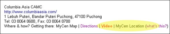
Screenshot above: Sample of a listing in Malaysia
Central with various ways to get to the address
In
order to access the "Mycen Location" feature,
you must have Google Earth already installed. Both
PC and Mac versions are available for free. You
can download
the latest version here.
A relatively new computer and broadband connection
is required for smooth viewing and navigation. If
you have a reasonably fast connection you can download
the program, install it and be up and running in
less than 10 minutes. Normally, you don't need to
restart your computer or shut down your browser
or any other programs.
After installation, clicking on any 'MyCen Location'
or 'Go there' link should launch Google Earth (if
it's not already opened). It will take you to the
specified location almost immediately. When you
do this for the first time, your browser may ask
to confirm whether you wish to use Google Earth
to open the kmz file type. After the program is
launched, it will take a few seconds to initialise
and log in. No user name, password or configuration
is required.
On the MyCen Location
Directory, you'll find three ways to get
to the specified place. You can click on the place
name to visit the website, click on "Go there"
to see the satellite image, click on Map
or see Directions (where available).

Screenshot above: MyCen
Location Directory offers three versatile ways
to check out a place


Screenshots above: A info tag appears also
on the sidebar with the address & originating
page from MyCen
To navigate, hold down left button to move about.
Use the zoom, tilt or rotate functions at the bottom
of the screen to have a closer or further view.
The mouse scroll wheel also acts as a zoom lever.
Or zoom by holding down the right mouse button and
then move the mouse up or down.

Screenshot above: The navigation control panel
on Google Earth interface

Sceenshot above: Use the tilt & rotate
function to vary your point of view & geographical
perspective
The resolution of the image vary and are streamed
from the servers as you move your position or viewpoint.
Wait for the streaming indicator to show 100% for
best quality. You can also export the coordinates
into GPS or navigation devices. Some places may
not have the latest images but it is being updated
from time to time. See also the official FAQ.

Sceenshot above: The streaming indicator.
Wait for it to reach 100% for maximum clarity
Tip: If you are unable to recognise a location,
keep Google Earth open and fire up a couple more
nearby places which you
are familiar. This may help you figure out the relative
position of the original placemark.
Tip: Look out for group or multiple placemarks (where
available). The link is highlighted
in red and offers you a snapshot
or bird's eye view of all nearby landmarks in the
vicinity. (see pic further down)
Tip: Take a guided tour from here.
Glide through a road or an area and familiarise
yourself with the various
landmarks.
Tip: Uncheck all the layers except terrain to reduce
clutter.
Tip: Rotate the image or reset compass to North
to see which direction your house or office is facing.
Tip: For IE and Firefox browsers in PCs, clicking
a link should open the placemarks. In cases (Mac)
where it fails to open
automatically, try saving it somewhere and open
the file manually through Google Earth.

Sceenshot above: Open different
placemarks sequentially to compare its distance
& direction to one another

Sceenshot above: Opening a red link where
related placemarks are grouped together (Brickfields
in this case)

Sceenshot above: If necessary, uncheck all
layers (except terrain) to reduce clutter
Ready to go places? Test by clicking on the various
places featured
here. For a fun and awesome experience ,
try clicking on Penang Bridge first and the Causeway
JB next. See it fly!
To ensure accuracy, on-the-ground verification with
GPS
is carried out where possible or practical. As such
it may take a while to grow the geographical coverage.
Maps where availabe
are linked together. So, refresh the pages regularly
as new locations are added on a daily basis.
Google
Earth is a trademark of Google, Inc. The use of
Google Earth is subject to the Google Terms Of Service.
Other brands, product names or place names may be
trademarks of their respective owners. Malaysia
Central (MyCen) is not affiliated with Google in
any way & is not responsible for its content
or operation. All placemark positioning, groupings,
tours, styles, overlays, description, info &
files here are the creation & copyright of Malaysia
Central. See our TOS.