|
MyCen Directions: Digital Mall, Petaling Jaya
|
Driving guide & ground directions with road maps, street pictures & information of the route, location or area
|
| Find Other Places: Directions & Map Index | Search For A Location | More Maps Here |
|
|
 MyCen Directions
Updated & Current
Clear & Accurate Maps
With Latest Landmarks
GPS Verified On Ground
Portal-Wide Useful Links
Picture Of Every Location
Comprehensive Information
Made With Local Knowledge
Each Place Visited In Person
Satellite & Google Earth View
Independent Opinion & Review

As Seen On TV's

|
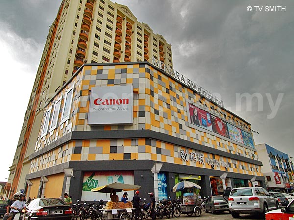
Digital Mall, Section 14, PJ
|
|
|
|
If interactive map above is slow to load or not showing, CLICK HERE for static view
|
|
|
|
|
| View the Full MyCen Events Calendar here |
|
Address: 2 Jalan 14/20, Section 14, Petaling Jaya, Selangor, Malaysia
Postcode (Poskod): 46100 Petaling Jaya
Tel: +603 7968 3311
Fax: +603 7968 3336
Website: http://www.digitalmall.com.my/
Area: Seksyen 14, Petaling Jaya, Selangor (Sel / D.E.)
Jurisdiction: Majlis Bandaraya Petaling Jaya - MBPJ (formerly MPPJ) (See Local Govt)
Events At This Location: See MyCen Events Calendar
Directions: From the Federal Highway, exit into Jalan Utara. Go pass Crystal Crown Hotel and turn right at the traffic lights. Turn left at the junction where the blue Menara CSM / Jaya Supermarket building is situated. Digital Mall is the building at the next corner, opposite RHB Bank. From Damansara or Taman Tun, take Jalan Dato Abu Bakar through to Jalan Kemajuan.
The shopping complex is also known as Menara SM and the Menara Bakti high-rise apartment building is behind and above it. Parking on the road is haphazard with many vehicles double-parked all the time. It is better to park at the basement parking in Jaya, at the MBBJ multi-storey car park behind the market / food court or in the Digital Mall building itself.
Info / Insights: Located in the commercial area of Section 14, the building is owned by SM Digital Mall Sdn Bhd. The building was previously occupied by Metrojaya. Digital Mall opened in January 2007 and adopts the IT-centric concept of Low Yat Plaza, although at a smaller scale. All four floors have shops selling PCs, Macs, PDAs, GPS devices, notebooks (laptops), memory, storage, computer accessories, parts and peripherals. Like most shopping centers, the ubiquitous mobile phone shops are there too. The mall has a net lettable area of 49,829 sq.ft. with 100% occupancy. Wi-fi is availble on all floors. All-IT Hypermart claims to be the largest computer retail centre in Malaysia, occupying the entire third floor of Digital Mall.
The property landscape in the area is changing very rapidly. The blue Jaya landmark will soon be demolished for re-constructing a bigger and taller replacement. Further down the road, the new Quill 9 @ PJ Semangat is scheduled for opening in September 2008.
Nearby Landmarks: Menara CSM - Jaya Shopping Centre (under re-cconstruction) (A), Jaya 33 (B),
Menara Jaya Condominium (C)
Surroundings: Millennium Square Condo (D), Sekolah Kebangsaan Sri Petaling (E), Sekolah Menengah Kebangsaan Bukit Bintang (G), Filem Negara (F), Astaka Sports Complex (I), Tun Hussein Onn National Eye Hospital - THONEH (J), Armada Hotel & Asia Jaya Complex (K), Nestle House (L), Menara Axis (O), Crystal Plaza (P), Amcorp Mall & Menara Amcorp (Q), A & W Drive-In, Taman Jaya (R), The Istara Condo (T), Cobra Club Clubhouse (U), Intan Square - Palms Cafe, Kelab Neptune, Restoran Imperial Garden (V), Malaysian Paintball Academy - MAPAAC (W), German School KL - Deutsche Schule Kuala Lumpur (Wisma KKAUM) (X)
(use zoom and navigation buttons on top left of map to explore)
Surrounding Roads: Jalan Semangat, Jalan Kemajuan, Jalan Universiti, Jalan Utara, Lorong Utara, Jalan Barat, Jalan Dato Jamil Rais, Federal Highway (Lebuhraya Persekutuan)
Nearby Hotels: Crystal Crown (H), Armada Hotel (K), PJ Hilton (N), Hotel Singgahsana (M), Shah's Village Hotel (S), Lisa De Inn, Eastin Hotel
(For telephone contact, full address & web site of each hotel, see our Hotel Listings)
Nearest Train Station: Asia Jaya LRT Station (1 km by taxi/bus)
Nearest Police Station: Balai Polis Sea Park
Bus Number:
Distance: 11.3 km from Low Yat Plaza (via Federal Highway)
GPS Coordinates & Position: N3 06.549 E101 38.183
Featured Category : Shopping Malls
Related Categories: PC Vendors | Mobile Phones | CCTV Equipment | Taxis | Transport
Connecting Maps: Thai Buddhist Chetawan Temple, Jalan Gasing
Amcorp Mall | Jaya One | Crystal Crown PJ |
|
|
| Find Other Places: Directions & Map Index | Search For A Location | More Maps Here |
Please help us refine the location information by sending additional info, suggestions, updates, comments to tvsmith@mycen.com.my
Maps powered by Google Maps unless otherwise stated. Additional geographical information, overlays, placemarks, waypoints, data, pictures and design created & owned by Malaysia Central & TV Smith. All rights reserved. No warranty on validity, completeness or accuracy given or implied. Use at your own risk. Property names, place names, location mark, point-of-interest, business names, designs, signs, graphics, symbols, icons, brands & logos are trademarks of their respective owners. |
| queries: photo, pics, image, gis, place, places, attraction, guide, streetmap, roadmap, building, site, streets, directory, roads, public transport, travel, get, go, going, getting, drive, driving, walk, direction, journey, lrt, ktm, cab, whereabouts, locate, about, how to go, where is, far, near, shortest, find, miles, from, lokasi, gambar, tempat, cari, cara, macam mana, di mana, bagaimana, pergi, ke, jalan, bangunan, wisma, teksi, peta, panduan, arahan, arah memandu, pandu, alamat, tapak, berdekatan, perjalanan, dari, laluan |
|
|
|
|