|
MyCen Directions: Hospital Ampang
|
Driving guide & ground directions with road maps, street pictures & information of the route, location or area
|
| Find Other Places: Directions & Map Index | Search For A Location | More Maps Here |
|
|
 MyCen Directions
Updated & Current
Clear & Accurate Maps
With Latest Landmarks
GPS Verified On Ground
Portal-Wide Useful Links
Picture Of Every Location
Comprehensive Information
Made With Local Knowledge
Each Place Visited In Person
Satellite & Google Earth View
Independent Opinion & Review

As Seen On TV's

|
|
|
|
|
If interactive map above is slow to load or not showing, CLICK HERE for static view
|
|
|
|
|
| View the Full MyCen Events Calendar here |
|
Address: Jalan Pandan Mewah 1, Pandan Mewah, Ampang, Selangor, Malaysia
Postcode (Poskod): 68000 Ampang
Tel: +603 4289 6000
Fax: +603 4295 4666
Website: http://www.moh.gov.my/
Area: Selangor Darul Ehsan (SEL D.E.)
Jurisdiction: Majlis Perbandaran Ampang Jaya - MPAJ (See Local Govt)
Directions: From MRR 2 southbound, turn left into Jalan Pandan Utama. With Menara MPAJ on your right, drive straight and turn right at the junction into Taman Pandan Mewah. Ampang Hospital is on your left, opposite a McDonald's drive-thru.
If you are coming from Ampang, you can also drive along Ampang Waterfront and turn right where the new Carrrefour is. Go up the hill and through several traffic lights till you reach the T-junction at the end of the road. Turn right into Pandan Mewah from there.
Info / Insights: You live in the Ampang area. The Ampang we all know. There is a medical emergency and you need to rush a family member to hospital. There are private hospitals nearby but you don't want to cough out your life savings for the admission deposit. So you head for the nearest government hospital you vaguely know. It will be another emergency when you find out that the Ampang Hospital is not really in Ampang and you need to navigate a very busy expressway to reach it. Just so you know in advance.
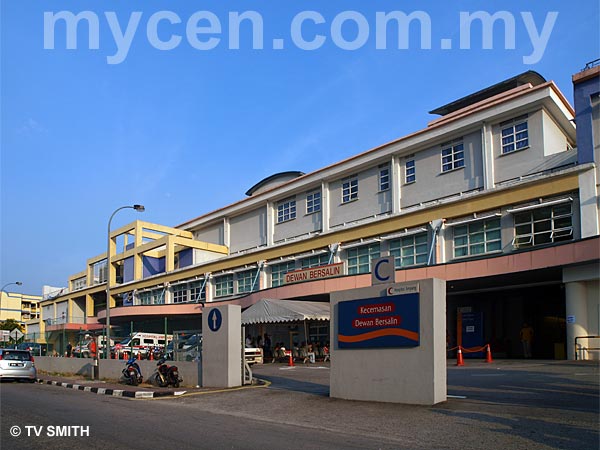
Opened in 2006, Hospital Ampang is actually in Pandan Mewah, on the edge of Pandan Indah, near Cheras. The 562-bed hospital is also used as a clinical training facility for medical students of the Islamic Science University of Malaysia (Universiti Sains Islam Malaysia - USIM, formerly KUIM).
Nearby Landmarks: Hata Square (A), Pong On Chinese School 2 (B), McDonalds (C)
Surroundings: Pandan Perdana, Pandan Mewah, Paragon Point Shopping Centre (D), Puteri Park Plaza (E), Puteri Court (F), Padang Perbandaran Ampang Jaya (G), Balai Bomba & Penyelamat Pandan Indah (H), Pandan Mewah Apartments (I), Pandan Mewah Heights Condo (J), Menara Maxisegar (L), Menara MPAJ, Menara Pandan (LHDN) & Pandan Kapital (M), Le Jardin Deluxe Condominium (N), Pantai Hospital Ampang (formerly Hospital Pantai Indah) (O), Grandeur Tower (P), Pandan Villa Condo (R), Steven's Corner (S), Mid-Point Shopping Centre & The Store (U), MRR2 - Middle Ring Road 2 (V), Road To Ampang (W)
(use zoom and navigation buttons on top left of map to explore)
Nearby Hotels: (see Hotel Listings)
Nearest Train Station: Pandan Indah LRT Station, Cempaka LRT Station, Tmn Cahaya LRT Station
Nearest Police Station: Balai Polis Pandan Indah (T), Tel: 03 9274 2514
Bus Number:
Distance: 6.3 km from Ampang Point via MRR 2
GPS Coordinates: N3 07.676 E101 45.843
Position on Google Earth:
Featured Category : Government Hospitals
Related Categories: Private Hospitals | Dentists | Clinics | Health | Florists | Insurance |
|
|
| Find Other Places: Directions & Map Index | Search For A Location | More Maps Here |
Please help us refine the location information by sending additional info, suggestions, updates, comments to tvsmith@mycen.com.my
Maps powered by Google Maps unless otherwise stated. Additional geographical information, overlays, placemarks, waypoints, data, pictures and design created & owned by Malaysia Central & TV Smith. All rights reserved. No warranty on validity, completeness or accuracy given or implied. Use at your own risk. Property names, place names, location mark, point-of-interest, business names, designs, signs, graphics, symbols, icons, brands & logos are trademarks of their respective owners. |
| queries: photo, pics, image, gis, place, places, attraction, guide, streetmap, roadmap, building, site, streets, directory, roads, public transport, travel, get, go, going, getting, drive, driving, walk, direction, journey, lrt, ktm, cab, whereabouts, locate, about, how to go, where is, far, near, shortest, find, miles, from, lokasi, gambar, tempat, cari, cara, macam mana, di mana, bagaimana, pergi, ke, jalan, bangunan, wisma, teksi, peta, panduan, arahan, arah memandu, pandu, alamat, tapak, berdekatan, perjalanan, dari, laluan |
|
|
|
|