|
MyCen Directions: Hospital Pusrawi, Kuala Lumpur
|
Driving guide & ground directions with road maps, street pictures & information of the route, location or area
|
| Find Other Places: Directions & Map Index | Search For A Location | More Maps Here |
|
|
 MyCen Directions
Updated & Current
Clear & Accurate Maps
With Latest Landmarks
GPS Verified On Ground
Portal-Wide Useful Links
Picture Of Every Location
Comprehensive Information
Made With Local Knowledge
Each Place Visited In Person
Satellite & Google Earth View
Independent Opinion & Review

As Seen On TV's

|
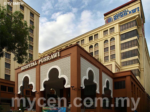
Hospital Pusrawi, Jalan Tun Razak, KL
|
|
|
|
If interactive map above is slow to load or not showing, CLICK HERE for static view
|
|
|
|
|
| View the Full MyCen Events Calendar here |
|
Address: Lot 149, Jalan Tun Razak, Kuala Lumpur, Malaysia
Postcode (Poskod): 50050 Kuala Lumpur
Tel: +603 2687 5000
Fax: +603 2688 5001
Website: http://www.pusrawi.com.my/
Area: Wilayah Persekutuan Kuala Lumpur, Federal Territory of Kuala Lumpur (KL / WP)
Jurisdiction: Dewan Bandaraya Kuala Lumpur DBKL - KL City Hall (See Local Govt)
Directions: From the direction of Jalan Mahameru, drive southbound to Jalan Tun Razak. After the flyover over Bulatan Pahang, keep to your left. Hospital Pusrawi is next to Hotel Putra KL and opposite IJN.
Info / Insights: PUSRAWI is an acronym for Pusat Rawatan Islam. It is a private hospital with its administration and treatment based on Islamic values. This specialist hospital has 90 beds with an emergency room and outpatient wards.
The organisation also operates a 24-hr clinic at Bangunan Baitulmal, Jalan Ipoh (next to Bangunan PERKIM). In addition, there are also several Klinik Am & Pakar branches under the Pusat Rawatan Islam umbrella at various locations in the Klang Valley.
Nearby Landmarks: Hotel Putra (A), Wisma Sejarah (B), Perpustakaan Negara (National Library) (C)
Surroundings Places: Wisma Bernama (D), Marinara (E), Menara CELCOM (F), Menara TH Selborn (G), KLGH (Kuala Lumpur General Hospital) (H), Institut Jantung Negara - IJN (I), National Blood Centre (J), National Art Gallery (K), Istana Budaya (L), The Orion Condo (O), AAM (P), Kompleks UKM Jalan Temerloh (Q)
(use zoom and navigation buttons on top left of map to explore)
Surrounding Roads: Taman Tasik Titiwangsa, Jalan Fletcher, Jalan Temerloh, Jalan Semarak (Gurney), Jalan Pahang, Jalan Raja Muda Aziz
Nearby Hotels: Hotel Putra KL, MiCasa All-Suites Hotel, Grand Seasons Hotel
(For telephone contact, full address & web site of individual hotel, see our Hotel Listings)
Nearest Train Station: Titiwangsa LRT Station, Chow Kit LRT Station (taxi required)
Nearest Police Station: Balai Polis Tun Razak, Tel: 03 2141 2222
Bus Number:
Distance:
GPS Coordinates & Position: N3 10.265 E101 42.586
Featured Category : Private Hospitals
Related Categories: Government Hospitals | Dentists | Clinics | Health | Florists | Insurance
Connecting Maps: Taman Tasik Titiwangsa | Menara Tan & Tan, Jalan Tun Razak
Dewan Perdana FELDA, Jalan Semarak | Kampung Baru KL
Vistana Hotel, Kompleks Damai |
|
|
| Find Other Places: Directions & Map Index | Search For A Location | More Maps Here |
Please help us refine the location information by sending additional info, suggestions, updates, comments to tvsmith@mycen.com.my
Maps powered by Google Maps unless otherwise stated. Additional geographical information, overlays, placemarks, waypoints, data, pictures and design created & owned by Malaysia Central & TV Smith. All rights reserved. No warranty on validity, completeness or accuracy given or implied. Use at your own risk. Property names, place names, location mark, point-of-interest, business names, designs, signs, graphics, symbols, icons, brands & logos are trademarks of their respective owners. |
| queries: photo, pics, image, gis, place, places, attraction, guide, streetmap, roadmap, building, site, streets, directory, roads, public transport, travel, get, go, going, getting, drive, driving, walk, direction, journey, lrt, ktm, cab, whereabouts, locate, about, how to go, where is, far, near, shortest, find, miles, from, lokasi, gambar, tempat, cari, cara, macam mana, di mana, bagaimana, pergi, ke, jalan, bangunan, wisma, teksi, peta, panduan, arahan, arah memandu, pandu, alamat, tapak, berdekatan, perjalanan, dari, laluan |
|
|
|
|