|
MyCen Directions: Plaza Damansara, Bukit Damansara
|
Driving guide & ground directions with road maps, street pictures & information of the route, location or area
|
| Find Other Places: Directions & Map Index | Search For A Location | More Maps Here |
|
|
 MyCen Directions
Updated & Current
Clear & Accurate Maps
With Latest Landmarks
GPS Verified On Ground
Portal-Wide Useful Links
Picture Of Every Location
Comprehensive Information
Made With Local Knowledge
Each Place Visited In Person
Satellite & Google Earth View
Independent Opinion & Review

As Seen On TV's

|
Plaza Damansara, Damansara Heights, Kuala Lumpur
|
|
|
|
If interactive map above is slow to load or not showing, CLICK HERE for static view
|
|
|
|
|
| View the Full MyCen Events Calendar here |
|
Address: Bukit Damansara (Damansara Heights), Kuala Lumpur, Malaysia
Postcode (Poskod): 50490 Kuala Lumpur
Tel:
Fax:
Website:
Area: Wilayah Persekutuan Kuala Lumpur, Federal Territory of Kuala Lumpur (KL / WP)
Jurisdiction: Dewan Bandaraya Kuala Lumpur DBKL - KL City Hall (See Local Govt)
Directions: From KL, circle around Pusat Bandar Damansara (DTC) and go up the slope (Jalan Johar) with Esso on your left and the new Twins on your right. Head straight after the traffic lights ahead. Plaza Damansara is at about 750 metres from the junction. Masjid Saidina Umar Al-Khattab will be on your right as you drive towards the commercial centre.
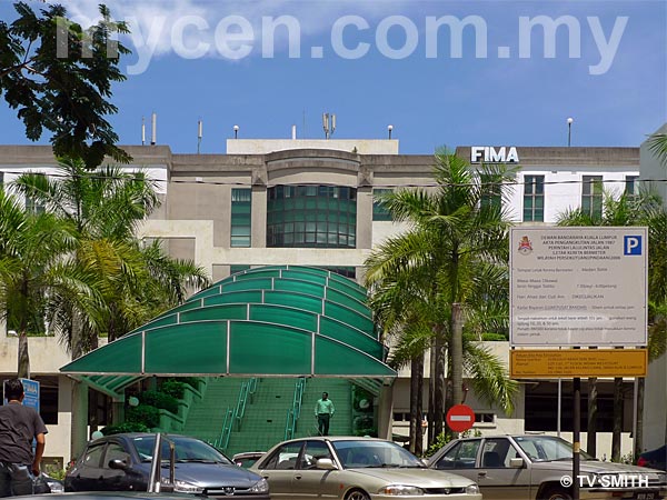
Info / Insights: Constructed in the early 1990s, Plaza Damansara is actually two rows of five-storey shophouses in an oval configuration. The East end is fronted by Menara SBB (now CIMB), while The Epicure is located on the West end. In the middle, lies the FIMA building or Block C.
Located in the middle of the Bukit Damansara residential area, parking space at Plaza Damansara seems somewhat inadequate in the day. At night, the place is quiet but several cozy restaurants and bistros like La Suisse, Escobar's, Flamenco, Deutsches Gasthaus, Chef & Brew (and others) attract patrons from near and far.
Nearby Landmarks: FIMA Berhad - Block C (1), CIMB Bank - Menara SBB (2), Epicure (3)
Surrounding Places: Maybank (4), La Suisse Swiss Cuisine (5), Escobar's Cigar, Wine & Coffee (6), Restoran & Bar Flamenco (7), Deutsches Gasthaus (8), Public Bank (9), Domino's Pizza (10),
Chiropractic Specialty Center - Pusat Kiropraktik (31), Dewan Perniagaan Melayu Malaysia - DPMM (32), VHQ Post (33), Pekan Kopitiam (34), Guardian Pharmacy (35), Betarecs (36), 7-Eleven (37),
Pondok Polis Bukit Damansara (51), Masjid Saidina Umar Al-Khattab Mosque (52), Sekolah Sri Cempaka School (Cempaka Schools, Damansara Campus) (53), Pusat Komuniti Bukit Damansara DBKL (54),
(use zoom and navigation buttons on top left of map to explore)
Surrounding Roads: Jalan Setia Murni, Jalan Medan Setia, Jalan Setiabudi, Jalan Setia Bakti, Jalan Setiaraya, Jalan Medan
Nearby Hotels: Peninsula Residence, Duta Vista
(For telephone contact, full address & web site of individual hotel, see our Hotel Listings)
Nearest Train Station: Bangsar LRT Station (taxi required)
Nearest Police Station: Pondok Polis Bukit Damansara (51), Tel: 03 2096 1300
Bus Number:
Distance:
GPS Coordinates & Position: N3 08.980 E101 39.190
Featured Category : Properties
Related Categories: Restaurants | Banks | Real Estate Agents
Connecting Maps: Damansara Town Center | Peninsula Residence Hotel, Jalan Semantan
Sime Darby Convention Centre, Bukit Kiara | HP Towers, Bukit Damansara
Bukit Damansara - Damansara Heights
|
|
|
| Find Other Places: Directions & Map Index | Search For A Location | More Maps Here |
Please help us refine the location information by sending additional info, suggestions, updates, comments to tvsmith@mycen.com.my
Maps powered by Google Maps unless otherwise stated. Additional geographical information, overlays, placemarks, waypoints, data, pictures and design created & owned by Malaysia Central & TV Smith. All rights reserved. No warranty on validity, completeness or accuracy given or implied. Use at your own risk. Property names, place names, location mark, point-of-interest, business names, designs, signs, graphics, symbols, icons, brands & logos are trademarks of their respective owners. |
| queries: photo, pics, image, gis, place, places, attraction, guide, streetmap, roadmap, building, site, streets, directory, roads, public transport, travel, get, go, going, getting, drive, driving, walk, direction, journey, lrt, ktm, cab, whereabouts, locate, about, how to go, where is, far, near, shortest, find, miles, from, lokasi, gambar, tempat, cari, cara, macam mana, di mana, bagaimana, pergi, ke, jalan, bangunan, wisma, teksi, peta, panduan, arahan, arah memandu, pandu, alamat, tapak, berdekatan, perjalanan, dari, laluan |
|
|
|
|