|
MyCen Directions: SPCA Selangor, Ampang Jaya
(Society for the Prevention of Cruelty to Animals)
|
Driving guide & ground directions with road maps, street pictures & information of the route, location or area
|
| Find Other Places: Directions & Map Index | Search For A Location | More Maps Here |
|
|
 MyCen Directions
Updated & Current
Clear & Accurate Maps
With Latest Landmarks
GPS Verified On Ground
Portal-Wide Useful Links
Picture Of Every Location
Comprehensive Information
Made With Local Knowledge
Each Place Visited In Person
Satellite & Google Earth View
Independent Opinion & Review

As Seen On TV's

|
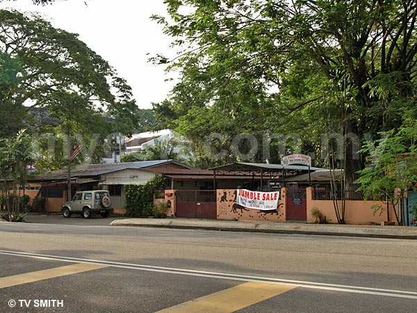
SPCA Selangor - Ampang Jaya
|
|
|
|
If interactive map above is slow to load or not showing, CLICK HERE for static view
|
|
|
|
|
| View the Full MyCen Events Calendar here |
|
Address: Jalan Kerja Ayer Lama, Ampang Jaya, Selangor, Malaysia
Postcode (Poskod): 68000 Ampang
Tel: +603 4256 5312
Fax: +603 4252 8382
Website: http://www.spca.org.my/
Area: Selangor Darul Ehsan (SEL D.E.)
Jurisdiction: Majlis Perbandaran Ampang Jaya - MPAJ (See Local Govt)
Events At This Location: See MyCen Events Calendar
Directions: From the Ulu Klang main road (MMR2) turn into Jalan Kerja Air Lama. The junction has a Petronas and Mobil station on each side. The Ampang Puteri Hospital can be seen behind the Mobil Station. You will see another Petronas with a McDonalds drive-through on your right. On your left are the Mutiara Grammar School, ISKL and MARDEC Building. Slow down when you see the row of shops with a 7-11 and food stalls (Studio 5 & Naan Corner). The SPCA is just after the short row of stalls and shops. You can also enter this road directly from the Ampang-KL Elevated Highway via the Ampang Jaya exit. This same road also leads to Taman TAR and Kelab Darul Ehsan (KDE).
Info: (from the SPCA website) The aim of the SPCA is to protect defenseless animals and to alleviate their suffering. Established in 1958, the SPCA provides temporary shelter to unwanted animals in Selangor and KL. These include mainly cats, dogs, rabbits, hamsters, guinea pigs ... usually pets that are no longer desired by their owners. From there, volunteers and staff try to re-home as many as possible but with more than 1,100 animals arriving every month (reaching some 13,000 annually), the shelter is constantly challenged by a shortage of space and limited funds. Help out by adopting the animals, volunteering, contributing money or donating stuff for their regular jumble sales.
The Malaysian SPCA is sometimes incorrectly referred to as RSPCA (Royal Society for the Prevention Of Cruelty to Animals).
Nearby Landmarks: AKLEH, Mutiara International Grammar School (F), ISKL (G), MARDEC (H), Kojaya Apartments (I), Kelab Darul Ehsan - KDE (E), Petronas (with McDonald's, MaxValu, Imbiss German Deli, Original Kayu Nasi Kandar) (M)
Surroundings: Jalan Kerja Ayer Lama, Jalan Ampang, Middle Ring Road 2 (Jalan Lingkaran Tengah 2), Taman TAR, Jalan Ampang Putra, Ampang Impiana Condo, Flamingo Institute (N),
1 Ampang Avenue (next to 'Little Korea' shops) (D), Ampang Puteri Hospital (L), Ampang Point Shopping Centre (A), Kompleks Sukan SunSuria (formerly Sports Planet) (C)
(use zoom and navigation buttons on top left of map to explore)
Nearby Hotels: De Palma Hotel (B), Flamingo Hotel (J) (see Hotel Listings)
Nearest Train Station: Ampang LRT Station (2.4 km by taxi & feeder bus)
Nearest Police Station: Balai Polis Ampang Tel: 03 4252 2222
Bus Number: RapidKL Bas U26
Distance: 5.6 km from KLCC via Jalan Ampang
GPS Coordinates: Latitude 3° 9'39.54"N Longtitude 101°45'33.48"E
Position on Google Earth: View MyCen Location (what's this?).
Main Map: Mycen Map Of KL City East - Ampang
Featured Category : Pets
Related Categories: NGOs | Associations | Vets | Town & City Councils | International Schools |
|
|
| Find Other Places: Directions & Map Index | Search For A Location | More Maps Here |
Please help us refine the location information by sending additional info, suggestions, updates, comments to tvsmith@mycen.com.my
Maps powered by Google Maps unless otherwise stated. Additional geographical information, overlays, placemarks, waypoints, data, pictures and design created & owned by Malaysia Central & TV Smith. All rights reserved. No warranty on validity, completeness or accuracy given or implied. Use at your own risk. Property names, place names, location mark, point-of-interest, business names, designs, signs, graphics, symbols, icons, brands & logos are trademarks of their respective owners. |
| queries: photo, pics, image, gis, place, places, attraction, guide, streetmap, roadmap, building, site, streets, directory, roads, public transport, travel, get, go, going, getting, drive, driving, walk, direction, journey, lrt, ktm, cab, whereabouts, locate, about, how to go, where is, far, near, shortest, find, miles, from, lokasi, gambar, tempat, cari, cara, macam mana, di mana, bagaimana, pergi, ke, jalan, bangunan, wisma, teksi, peta, panduan, arahan, arah memandu, pandu, alamat, tapak, berdekatan, perjalanan, dari, laluan |
|
|
|
|