|
MyCen Directions: St. John's Cathedral, Kuala Lumpur
|
Driving guide & ground directions with road maps, street pictures & information of the route, location or area
|
| Find Other Places: Directions & Map Index | Search For A Location | More Maps Here |
|
|
 MyCen Directions
Updated & Current
Clear & Accurate Maps
With Latest Landmarks
GPS Verified On Ground
Portal-Wide Useful Links
Picture Of Every Location
Comprehensive Information
Made With Local Knowledge
Each Place Visited In Person
Satellite & Google Earth View
Independent Opinion & Review

As Seen On TV's

|
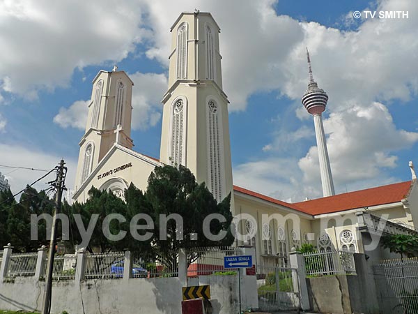
Cathedral of St. John, KL
|
|
|
|
|
|
|
|
|
| View the Full MyCen Events Calendar here |
|
Address: 5 Jalan Bukit Nanas,
Kuala Lumpur, Malaysia
Postcode (Poskod): 50250 Kuala Lumpur
Tel: +603 2078 1876
Fax: +603 2070 5899
Website: http://www.stjohnkl.org/
Area: Wilayah Persekutuan Kuala Lumpur, Federal Territory of Kuala Lumpur (KL / WP)
Jurisdiction: Dewan Bandaraya Kuala Lumpur DBKL - KL City Hall (See Local Govt)
Directions: From Jalan Raja Chulan, turn right into Jalan Gereja. At the first set of lights, turn right into Jalan Bukit Nanas
Info / Insights: This Roman Catholic church under the Archdiocese of Kuala Lumpur.is one of Kuala Lumpur's oldest buildings. It was built in 1883. Next to it, is the St John's Institution, a Christian mission school started by the Lasallian Brothers
Related: St Anne Sanctuary
Nearby Landmarks: St John's Institution (A), Menara Olympia (B), Muzium Telekom (C)
Surrounding Places: Ming Building (D), Convent Bukit Nanas - CBN (E), Menara AIA (F), Wisma Chartis (formerly AIG) (G), Bangunan Dato Zainal (H), Wisma Char Yong (I), Bukit Nanas Forest Reserve (J), Selangor Mansion (K), Malayan Mansion (L), Masjid India Mosque (M), Sri Bunus (N), Jakel Gedung Tekstil (P), Masjid Jamek (S), CapSquare (U),
Lebuh Ampang (V), Haniffa Textiles - Wisma Shen (W), Bazar Masjid India (X), Wisma Yakin, (Y), Gedung Borong Mydin (Z)
(use zoom and navigation buttons on top left of map to explore)
Surrounding Roads: Jalan Gereja, Jalan Ampang, Jalan Raja Chulan, Jalan Tun Perak, Bukit Nanas, Jalan Munshi Abdullah, Jalan Melaka, Jalan Masjid India, Leboh Ampang
Nearby Hotels: Garden City Hotel (O), Hotel MACKT Comfort Inn (Q), Champagne Hotel (R), Maytower Hotel & Serviced Apartment (T)
(For telephone contact, full address & web site of individual hotel, see our Hotel Listings)
Nearest Train Station: Bukit Nanas LRT Station, Masjid Jamek LRT Station
Nearest Police Station: Balai Polis Masjid India, Tel: 03 2692 6022
Bus Number:
Distance:
GPS Coordinates & Position: N3 08.990 E101 41.956
Featured Category : Christianity
Related Categories: Religion
Connecting Maps: Hentian Puduraya | Bursa Malaysia | CapSquare | Menara Hap Seng
Changkat Bukit Bintang | Jalan Masjid India |
|
|
| Find Other Places: Directions & Map Index | Search For A Location | More Maps Here |
Please help us refine the location information by sending additional info, suggestions, updates, comments to tvsmith@mycen.com.my
Maps powered by Google Maps unless otherwise stated. Additional geographical information, overlays, placemarks, waypoints, data, pictures and design created & owned by Malaysia Central & TV Smith. All rights reserved. No warranty on validity, completeness or accuracy given or implied. Use at your own risk. Property names, place names, location mark, point-of-interest, business names, designs, signs, graphics, symbols, icons, brands & logos are trademarks of their respective owners. |
| queries: photo, pics, image, gis, place, places, attraction, guide, streetmap, roadmap, building, site, streets, directory, roads, public transport, travel, get, go, going, getting, drive, driving, walk, direction, journey, lrt, ktm, cab, whereabouts, locate, about, how to go, where is, far, near, shortest, find, miles, from, lokasi, gambar, tempat, cari, cara, macam mana, di mana, bagaimana, pergi, ke, jalan, bangunan, wisma, teksi, peta, panduan, arahan, arah memandu, pandu, alamat, tapak, berdekatan, perjalanan, dari, laluan |
|
|
|
|