|
MyCen Directions: Balai Polis Trafik Jalan Tun H.S. Lee
|
Driving guide & ground directions with road maps, street pictures & information of the route, location or area
|
| Find Other Places: Directions & Map Index | Search For A Location | More Maps Here |
|
|
 MyCen Directions
Updated & Current
Clear & Accurate Maps
With Latest Landmarks
GPS Verified On Ground
Portal-Wide Useful Links
Picture Of Every Location
Comprehensive Information
Made With Local Knowledge
Each Place Visited In Person
Satellite & Google Earth View
Independent Opinion & Review

As Seen On TV's

|
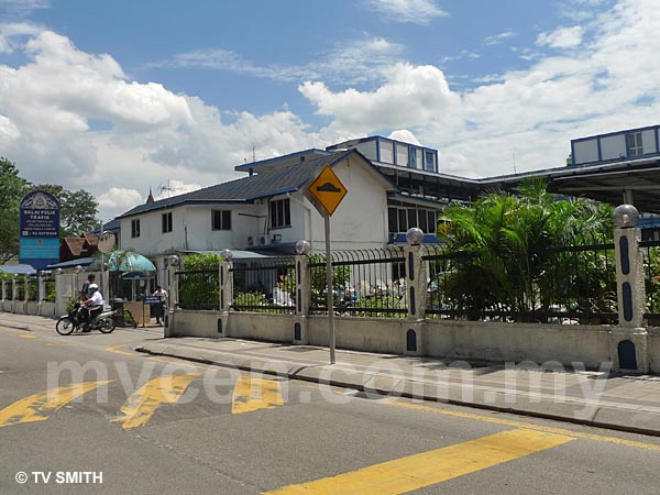
Jalan Bandar (High Street) Traffic Police Station, Kuala Lumpur
|
|
|
|
|
|
|
|
|
| View the Full MyCen Events Calendar here |
|
Address: Jalan Tun H.S. Lee, Kuala Lumpur
Postcode (Poskod): 50000 Kuala Lumpur
Tel: +603 2071 9999
Fax:
Website: http://www.rmp.gov.my/
Area: Wilayah Persekutuan Kuala Lumpur, Federal Territory of Kuala Lumpur (KL / WP)
Jurisdiction: Dewan Bandaraya Kuala Lumpur DBKL - KL City Hall (See Local Govt)
Directions: If you are going there to settle a summons (saman) or to clear your name from the blacklist (senarai hitam), take a train to the Pasar Seni LRT station and walk from there. It will save you a lot of hassle. For road accident reports, you may need to drive (or tow) your damaged vehicle there for photography or inspection. By car, drive into Jalan Sultan from Puduraya or Jalan Petaling from Bulatan Merdeka. Turn left at the traffic lights junction before 'Toshiba'. The streets in the area are mostly one-way. So, if you miss the turn, you would need to go one big round through the usually chaotic and congested area. There is a big but non-free car park across the police station. Beware of touts hanging inside and outside the station.
Info / Insights: The name of the street where the KL city traffic police station stands is itself a crash victim. The name was thrashed about with impunity by local authorities brandishing whimsical policies. As a result, the police station was renamed from High Street Police Station to Balai Polis Trafik Jalan Bandar to the current Balai Polis Trafik Jalan Tun H.S. Lee.
To add to the confusion, the regular police station for the area is named Balai Polis Tun H.S. Lee, located at Jalan Stadium (X on map).
Tun Sir Henry H.S. Lee was Malaysia's first Finance Minister.
Nearby Landmarks: Klang Bus Station (aka "Toshiba" Bus Terminal) (A), Plaza Warisan (B), Auditorium Taman Budaya Kuala Lumpur (C)
Surrounding Places: Ocean Shopping Centre & UO Superstore (D), Sri Maha Mariamman Temple Chinatown (E), Central Market & Central Market Annexe (G), Kota Raya Complex (H), S & M Complex - Wisma Fui Chui (I), Sinar Kota & Mydin (J), Bangunan Cahaya Suria (K), Menara Maybank (M), Wesley Methodist Church (N), Hentian Puduraya (Bus Terminal & Puduraya Hotel) (O), Chinatown KL, Petaling Street (P), Stadium Negara (U), Merdeka Stadium (V), Chin Woo Stadium (W), Chinese Assembly Hall (Y), Dayabumi Complex, Pejabat Pos Besar - General Post Office GPO & City Point Mall (Z)
(use zoom and navigation buttons on top left of map to explore)
Surrounding Roads: Jalan Tun Tan Cheng Lock (Foch Avenue), Jalan Tun Tan Siew Sin, Lebuh Pasar Besar, Jalan Sultan, Jalan Petaling, Bulatan Merdeka, Jalan Hang Lekir (Cecil Street), Jalan Hang Jebat (Davidson Road), Jalan Maharajaleela (Birch Road), Jalan Pudu, Jalan Pudu Lama, Jalan Kinabalu
Nearby Hotels: Hotel Malaya (F), Ancasa Hotel (L), The 5 Elements Hotel, Komplek Selangor (Q), Puduraya Hotel (O), Hotel Mandarin Pacific (R), Swiss Inn (S), Grand Olympic Hotel (T)
(For telephone contact, full address & web site of individual hotel, see our Hotel Listings)
Nearest Train Station: Pasar Seni LRT Station, Maharajaleela LRT Station, Plaza Rakyat LRT Station, (all within walking distance)
Nearest Police Station: Balai Polis Tun H.S. Lee
Bus Number:
Distance:
GPS Coordinates & Position: N3 08.492 E101 41.764
Featured Category : Government
Related Categories: Workshops | Insurance | Motoring
Connecting Maps: Hentian Puduraya Bus Terminal | Balai Polis Tun HS Lee, Jalan Stadium
Changkat Bukit Bintang | Chin Woo Stadium | Chinese Assembly Hall
Bangunan Sultan Abdul Samad, Dataran Merdeka |
|
|
| Find Other Places: Directions & Map Index | Search For A Location | More Maps Here |
Please help us refine the location information by sending additional info, suggestions, updates, comments to tvsmith@mycen.com.my
Maps powered by Google Maps unless otherwise stated. Additional geographical information, overlays, placemarks, waypoints, data, pictures and design created & owned by Malaysia Central & TV Smith. All rights reserved. No warranty on validity, completeness or accuracy given or implied. Use at your own risk. Property names, place names, location mark, point-of-interest, business names, designs, signs, graphics, symbols, icons, brands & logos are trademarks of their respective owners. |
| queries: photo, pics, image, gis, place, places, attraction, guide, streetmap, roadmap, building, site, streets, directory, roads, public transport, travel, get, go, going, getting, drive, driving, walk, direction, journey, lrt, ktm, cab, whereabouts, locate, about, how to go, where is, far, near, shortest, find, miles, from, lokasi, gambar, tempat, cari, cara, macam mana, di mana, bagaimana, pergi, ke, jalan, bangunan, wisma, teksi, peta, panduan, arahan, arah memandu, pandu, alamat, tapak, berdekatan, perjalanan, dari, laluan |
|
|
|
|