|
MyCen Directions: Prince Court Medical Centre
|
Driving guide & ground directions with road maps, street pictures & information of the route, location or area
|
| Find Other Places: Directions & Map Index | Search For A Location | More Maps Here |
|
|
 MyCen Directions
Updated & Current
Clear & Accurate Maps
With Latest Landmarks
GPS Verified On Ground
Portal-Wide Useful Links
Picture Of Every Location
Comprehensive Information
Made With Local Knowledge
Each Place Visited In Person
Satellite & Google Earth View
Independent Opinion & Review

As Seen On TV's

|
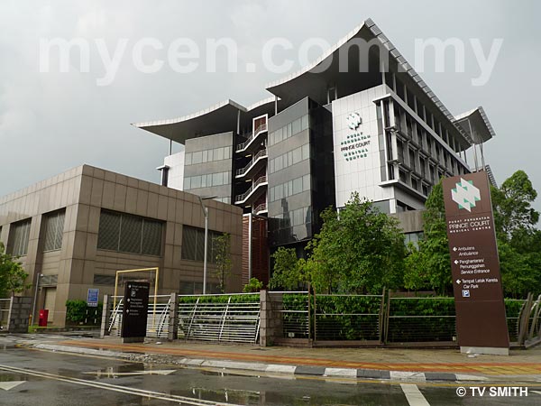
Pusat Perubatan Prince Court
|
|
|
|
|
|
|
|
|
| View the Full MyCen Events Calendar here |
|
Address: 39 Jalan Kia Peng, 50450 Kuala Lumpur, Malaysia
Postcode (Poskod): 50450 Kuala Lumpur
Tel: +603 2160 0000
Fax: +603 2160 0010
Website: http://www.princecourt.com/
Area: Wilayah Persekutuan Kuala Lumpur, Federal Territory of Kuala Lumpur (KL / WP)
Jurisdiction: Dewan Bandaraya Kuala Lumpur DBKL - KL City Hall (See Local Govt)
Directions: If you are approaching via Jalan Tun Razak (northbound), keep left after exiting the SMART Tunnel. Keep going straight at the traffic lights after the Indonesian Embassy instead of turning left into Jalan Bukit Bintang. Jalan Kia Peng is the first turning on the left after the lights. The hospital at the corner is visible even before entering this road.
Info: The 300-bed Prince Court Medical Centre is a private healthcare facility fully owned by Petronas. It is
affilliated with the Medical University of Vienna. MUV will provide Prince Court Medical Centre with a rotation of 15 senior clinical specialists each year.
Prince Court Medical Centre (PCMC) is also informally known as the Petronas Hospital or the 5-Star Hospital.
Nearby Landmarks: Embassy Of The State Of Kuwait (1), Wisma Kebudayaan SGM - Soka Gakkai Malaysia (2), Istana Terengganu (3)
Surrounding Places: Royal Selangor Golf Club - RSGC (4), Embassy Of The Republic Of Indonesia - Kedutaan Besar Republik Indonesia (6), Menara Yayasan Tun Razak (7), Kompleks Kraft (8), Royale Chulan Hotel (9), Chulan Tower (10), Bangunan LTAT - Lembaga Tabung Angkatan Tentera (11), Chulan Square DiningRow (12), The Ritz-Carlton Hotel Kuala Lumpur (13), The Westin Hotel Kuala Lumpur (14), JW Marriot Hotel (15), Dorsett Regency Hotel (16), Wisma Keck Seng (17),
Prince Hotel & Residence (18), Wisma MISC (19), Hakka Restaurant (20), Seri Melayu Restaurant (21), Badan Warisan (22), Pavilion KL (23), Istana Kelantan (24), Bintang Goldhill Condo (25), Wisma Technip (26), RHB Centre Jalan Tun Razak (27), Ibunda Malay Fine Dining Restaurant (28), Passage Through India Restaurant (29), Embassy Of Japan (30), Hotel Sempurna (31)
(use zoom and navigation buttons on top left of map to explore)
Surrounding Roads: Jalan Tun Razak, Jalan Bukit Bintang, Jalan Raja Chulan, Jalan Kia Peng, Jalan Eaton, Jalan Conlay, Jalan Langgak Golf, Jalan Imbi, Persiaran Stonor, Jalan Kelab Golf, Jalan Inail, Jalan Jati, Jalan Kemuning, Jalan Utara, Jalan Gasing, Jalan Walter Grenier
Nearby Hotels: Royale Chulan Hotel (9), The Ritz-Carlton Hotel Kuala Lumpur (13), The Westin Hotel Kuala Lumpur (14), JW Marriot Hotel (15), Dorsett Regency Hotel (16), Prince Hotel & Residence (18) Hotel Sempurna (31), See also: Hotels In Bukit Bintang
(For telephone contact, full address & web site of individual hotel, see our Hotel Listings)
Nearest Train Station: Raja Culan LRT Station
Nearest Police Station: Balai Polis Tun Razak, Tel:
Bus Number:
Distance:
GPS Coordinates & Position: N3 08.919 E101 43.329
Featured Category : Private Hospitals
Related Categories: Government Hospitals | Dentists | Clinics | Health | Ambulance | Insurance
Connecting Maps: Kompleks Kraft, Jalan Conlay | Menara Tan & Tan, Jalan Tun Razak
Pasar Rakyat, Imbi | Fraser Business Park, Sg Besi | Pasar Road, Pudu
|
|
|
| Find Other Places: Directions & Map Index | Search For A Location | More Maps Here |
Please help us refine the location information by sending additional info, suggestions, updates, comments to tvsmith@mycen.com.my
Maps powered by Google Maps unless otherwise stated. Additional geographical information, overlays, placemarks, waypoints, data, pictures and design created & owned by Malaysia Central & TV Smith. All rights reserved. No warranty on validity, completeness or accuracy given or implied. Use at your own risk. Property names, place names, location mark, point-of-interest, business names, designs, signs, graphics, symbols, icons, brands & logos are trademarks of their respective owners. |
| queries: photo, pics, image, gis, place, places, attraction, guide, streetmap, roadmap, building, site, streets, directory, roads, public transport, travel, get, go, going, getting, drive, driving, walk, direction, journey, lrt, ktm, cab, whereabouts, locate, about, how to go, where is, far, near, shortest, find, miles, from, lokasi, gambar, tempat, cari, cara, macam mana, di mana, bagaimana, pergi, ke, jalan, bangunan, wisma, teksi, peta, panduan, arahan, arah memandu, pandu, alamat, tapak, berdekatan, perjalanan, dari, laluan |
|
|
|
|