|
MyCen Directions: Tun Razak Hockey Stadium
|
Driving guide & ground directions with road maps, street pictures & information of the route, location or area
|
| Find Other Places: Directions & Map Index | Search For A Location | More Maps Here |
|
|
 MyCen Directions
Updated & Current
Clear & Accurate Maps
With Latest Landmarks
GPS Verified On Ground
Portal-Wide Useful Links
Picture Of Every Location
Comprehensive Information
Made With Local Knowledge
Each Place Visited In Person
Satellite & Google Earth View
Independent Opinion & Review

As Seen On TV's

|
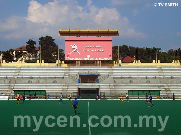
Stadium Hoki Tun Razak, Jalan Duta, Kuala Lumpur
|
|
|
|
|
|
|
|
|
| View the Full MyCen Events Calendar here |
|
Address: Persiaran Duta, Kuala Lumpur, Malaysia
Postcode (Poskod): 50480 Kuala Lumpur
Tel: +603 6201 5482
Fax:
Website: http://www.stadium.gov.my/
Area: Wilayah Persekutuan Kuala Lumpur, Federal Territory of Kuala Lumpur (KL / WP)
Jurisdiction: Dewan Bandaraya Kuala Lumpur DBKL - KL City Hall (See Local Govt / KL Map)
Directions: From Jalan Kuching northbound, keep left when you approach the Segambut Interchange. Turn left (9 o'clock on the roundabout) into Jalan Duta. Go pass the Tennis Stadium on your left and turn left when you see the Hentian Duta (Bus Terminal) sign. The MSN tennis courts are on the left at the junction of Persiaran Duta and the Tun Razak Hockey Stadium's entrance is a little further up to your right.
Info / Insights: The Tun Razak Hockey Stadium (Stadium Hoki Tun Razak) is now managed by the National Sports Complex Malaysia (Kompleks Sukan Negara - KSN), an agency under the Ministry of Youth & Sports.
The hockey stadium was the first astroturf stadium to be built in South-East Asia. Constructed in 1982 at the cost of RM 11 million, it saw some glorious action before it was eclipsed by the newer National Hockey Stadium at the Bukit Jalil Sport Complex.
Located within the stadium car park, is (the former) Pusat Skuasy Negara or the National Squash Centre courts.
Nearby Landmarks: Hentian Bas Duta (A), Masjid Wilayah Persekutuan (B), Kompleks Tenis - Jalan Duta Tennis Stadium (C)
Surrounding Places: LHDN Jalan Duta & Government Office Complex (D), Institut Integriti Malaysia - IIM (E), Gelanggang Skuasy Majlis Sukan Negara - MSN Squash Courts Jalan Duta (F), National Archives (G), Gelanggang Tenis Majlis Sukan Negara Jalan Duta - MSN Tennis Courts (H), Institut Kefahaman Islam Malaysia - IKIM - Institute of Islamic Understanding Malaysia (I), Jabatan Pelajaran Wilayah Persekutuan Kuala Lumpur (J), Kompleks Mahkamah Kuala Lumpur - KL Court Complex (K), Hartamas Heights (L), Menara Matrade & MECC (M), Solaris Dutamas (N), Duta Tropika Gated Homes (O), Lembaga Peperiksaan - Examinations Board (P), Pusat Penjaja Selera Duta (Q), Taman Tunku Apartments, Kenny Hills (R), Malaysia Anti-Corruption Academy (MACA) - Akademi Pencegahan Rasuah Malaysia (S), International Institute of Islamic Thought and Civilization - ISTAC (T)
(use zoom and navigation buttons on top left of map to explore)
Surrounding Roads: Jalan Duta, Jalan Kuching, Jalan Segambut, Jalan Khidmat Usaha, Jalan Ibadah, Jalan Dutamas, Jalan Sri Hartamas, Langgak Tunku, DUKE, NKVE
Nearby Hotels: Duta Vista, Peninsula Residence (see Hotel Listings)
Nearest Train Station: KTM Komuter Sentul Railway Station (3.4 km via Jalan Ipoh by taxi)
Nearest Police Station: Balai Polis Sentul, Tel: 03 4042 2222
Bus Number:
Distance: 3.7 km from Hentian Putra via Jalan Kuching, 6.1 km from Puduraya via Jalan Kuching
GPS Coordinates: N3 10.210 E101 40.412
Position on Google Earth: View MyCen Location (what's this?).
Featured Category : Sports
Related Categories: Venues | Ticketing
Connecting Maps: Soho KL, Solaris Mont Kiara | Plaza Sentul | Plaza Damas, Hartamas
DUKE | Hentian Duta |
|
|
| Find Other Places: Directions & Map Index | Search For A Location | More Maps Here |
Please help us refine the location information by sending additional info, suggestions, updates, comments to tvsmith@mycen.com.my
Maps powered by Google Maps unless otherwise stated. Additional geographical information, overlays, placemarks, waypoints, data, pictures and design created & owned by Malaysia Central & TV Smith. All rights reserved. No warranty on validity, completeness or accuracy given or implied. Use at your own risk. Property names, place names, location mark, point-of-interest, business names, designs, signs, graphics, symbols, icons, brands & logos are trademarks of their respective owners. |
| queries: photo, pics, image, gis, place, places, attraction, guide, streetmap, roadmap, building, site, streets, directory, roads, public transport, travel, get, go, going, getting, drive, driving, walk, direction, journey, lrt, ktm, cab, whereabouts, locate, about, how to go, where is, far, near, shortest, find, miles, from, lokasi, gambar, tempat, cari, cara, macam mana, di mana, bagaimana, pergi, ke, jalan, bangunan, wisma, teksi, peta, panduan, arahan, arah memandu, pandu, alamat, tapak, berdekatan, perjalanan, dari, laluan |
|
|
|
|