|
MyCen Directions: Gleneagles Intan Medical Centre
|
Driving guide & ground directions with road maps, street pictures & information of the route, location or area
|
| Find Other Places: Directions & Map Index | Search For A Location | More Maps Here |
|
|
 MyCen Directions
Updated & Current
Clear & Accurate Maps
With Latest Landmarks
GPS Verified On Ground
Portal-Wide Useful Links
Picture Of Every Location
Comprehensive Information
Made With Local Knowledge
Each Place Visited In Person
Satellite & Google Earth View
Independent Opinion & Review

As Seen On TV's

|
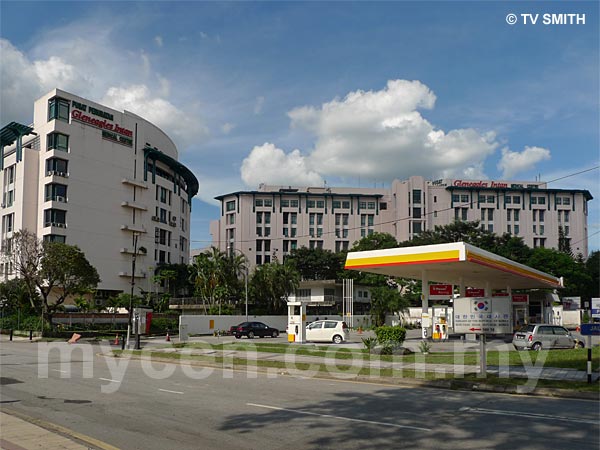
Pusat Perubatan Gleneagles Intan
|
|
|
|
If interactive map above is slow to load or not showing, CLICK HERE for static view
|
|
|
|
|
| View the Full MyCen Events Calendar here |
|
Address: 282 & 286 Jalan Ampang,
Kuala Lumpur, Malaysia
Postcode (Poskod): 50450 Kuala Lumpur
Tel: +603 03 4257 1300 (General), +603 4255 2880 (Emergency)
Fax:
Website: http://gimc.tmsasia.com/
Area: Wilayah Persekutuan Kuala Lumpur, Federal Territory of Kuala Lumpur (KL / WP)
Jurisdiction: Dewan Bandaraya Kuala Lumpur DBKL - KL City Hall (See Local Govt / KL Map)
Directions: From KL proceed along Jalan Ampang till Jalan Jelatek junction. After this junction you will see the Great Eastern Mall on your right. The hospital is ahead on the left, behind a Shell petrol station.
Info:
(from their website): Gleneagles Intan Medical Centre, Kuala Lumpur, comprises a 330-bed tertiary care hospital and a separate Medical Office Building (MOB) accommodating consultants of various specialties and sub-specialties for outpatient services.
The MOB comprises 110 specialists consulting suites, a 180-seat auditorium on the top floor with a retail pharmacy, a bank and a cafe the ground floor. Specialists practicing in the MOB are independent practitioners.
Nearby Landmarks: Shahzan Court Condo (A), Ampangpuri Condo (B), Embassy Of The Republic Of Korea (C)
Surroundings: Jalan Ampang, Jalan Nipah, Jalan Jelatek, Jalan Ampang Hilir, Jalan Mengkuang, Lorong Ru, Great Eastern Mall & Menara Great Eastern (D), Menara PERKESO (SOCSO) (E), Fairview International School (F), Kompleks Perumahaan Angkatan Tentera - Desa Pasifik (G), Ibu Pejabat Kebangsaan, Bulan Sabit Merah Malaysia - National Headquarters, Malaysian Red Crescent Society (H), Pusat Kawalan SMART Control Centre (I), Torino Motor Industries - Fiat Showroom (J), Nihonkan Club (N), Bangunan RISDA (R)
(use zoom and navigation buttons on top left of map to explore)
Nearby Hotels: Holiday Villa, Sucasa, De Palma Hotel, Flamingo Hotel (see Hotel Listings)
Nearest Train Station: Jelatek LRT Station
Nearest Police Station: Balai Polis Tun Razak, Tel:
Bus Number:
Distance:
GPS Coordinates: N3 09.692 E101 44.333
Position on Google Earth:
Main Map: Mycen Map Of KL City East - Ampang
Featured Category : Private Hospitals
Related Categories: Government Hospitals | Dentists | Clinics | Health | Ambulance | Insurance
Connecting Maps: Kelab Aman, Jalan Damai | Plaza Ampang City, Jalan Ampang
Great Eastern Mall, Jalan Ampang
|
|
|
| Find Other Places: Directions & Map Index | Search For A Location | More Maps Here |
Please help us refine the location information by sending additional info, suggestions, updates, comments to tvsmith@mycen.com.my
Maps powered by Google Maps unless otherwise stated. Additional geographical information, overlays, placemarks, waypoints, data, pictures and design created & owned by Malaysia Central & TV Smith. All rights reserved. No warranty on validity, completeness or accuracy given or implied. Use at your own risk. Property names, place names, location mark, point-of-interest, business names, designs, signs, graphics, symbols, icons, brands & logos are trademarks of their respective owners. |
| queries: photo, pics, image, gis, place, places, attraction, guide, streetmap, roadmap, building, site, streets, directory, roads, public transport, travel, get, go, going, getting, drive, driving, walk, direction, journey, lrt, ktm, cab, whereabouts, locate, about, how to go, where is, far, near, shortest, find, miles, from, lokasi, gambar, tempat, cari, cara, macam mana, di mana, bagaimana, pergi, ke, jalan, bangunan, wisma, teksi, peta, panduan, arahan, arah memandu, pandu, alamat, tapak, berdekatan, perjalanan, dari, laluan |
|
|
|
|