|
MyCen Directions: Great Eastern Mall & Menara Great Eastern
|
Driving guide & ground directions with road maps, street pictures & information of the route, location or area
|
| Find Other Places: Directions & Map Index | Search For A Location | More Maps Here |
|
|
 MyCen Directions
Updated & Current
Clear & Accurate Maps
With Latest Landmarks
GPS Verified On Ground
Portal-Wide Useful Links
Picture Of Every Location
Comprehensive Information
Made With Local Knowledge
Each Place Visited In Person
Satellite & Google Earth View
Independent Opinion & Review

As Seen On TV's

|
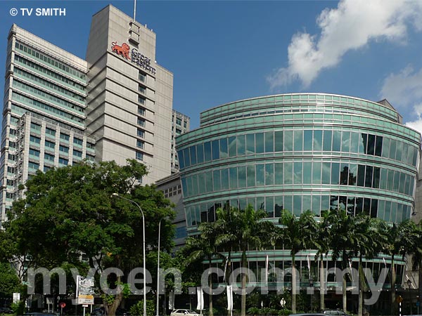
Great Easten Mall & Great Eastern Tower
|
|
|
|
If interactive map above is slow to load or not showing, CLICK HERE for static view
|
|
|
|
|
| View the Full MyCen Events Calendar here |
|
Address: 303 Jalan Ampang,
Kuala Lumpur, Malaysia
Postcode (Poskod): 50450 Kuala Lumpur
Tel: +603 4259 8090
Fax: +603 4256 9322
Website: http://www.greateasternmall.com.my/
Area: Wilayah Persekutuan Kuala Lumpur, Federal Territory of Kuala Lumpur (KL / WP)
Jurisdiction: Dewan Bandaraya Kuala Lumpur DBKL - KL City Hall (See Local Govt / KL Map)
Events At This Location: See MyCen Events Calendar
Directions: From KL proceed along Jalan Ampang till Jalan Jelatek junction. The SOCSO (PERKESO) building is on the right. Further up the junction is the Great Eastern Mall on your right. Parking is in the basement.
Info: Owned by one of the oldest insurance companies in Malaysia, the Great Eastern Mall is adjoined to an office tower block known as Menara Great Eastern. Among the outlets in the shopping mall are Cold Storage, Guardian Pharmacy and the Alexis Jazz Bistro.
Nearby Landmarks: Gleneagles Medical Centre, Bangunan RISDA, Plaza Ampang City
Surroundings: Jalan Ampang Hilir, Jalan Jelatek, Jalan Datuk Keramat, Menara PERKESO (SOCSO), Russia Embassy, Embassy of China, British High Commission, Embassy Of France, Ulu Kelang, Ampang Jaya, Jalan U-Thant, Ampang-KL Elevated Highway AKLEH
(use zoom and navigation buttons on top left of map to explore)
Nearby Hotels: Holiday Villa, Sucasa, Lanson Place, De Palma, Flamingo Hotel (see Hotel Listings)
Nearest Train Station: Jelatek LRT Station
Nearest Police Station: Balai Polis Tun Razak, Tel:
Bus Number: RapidKL U22, U26, U28, U29, U30, U34
Distance:
GPS Coordinates:
Position on Google Earth:
Main Map: Mycen Map Of KL City East - Ampang
Featured Category : Shopping Malls
Related Categories: Properties | Insurance |
|
|
| Find Other Places: Directions & Map Index | Search For A Location | More Maps Here |
Please help us refine the location information by sending additional info, suggestions, updates, comments to tvsmith@mycen.com.my
Maps powered by Google Maps unless otherwise stated. Additional geographical information, overlays, placemarks, waypoints, data, pictures and design created & owned by Malaysia Central & TV Smith. All rights reserved. No warranty on validity, completeness or accuracy given or implied. Use at your own risk. Property names, place names, location mark, point-of-interest, business names, designs, signs, graphics, symbols, icons, brands & logos are trademarks of their respective owners. |
| queries: photo, pics, image, gis, place, places, attraction, guide, streetmap, roadmap, building, site, streets, directory, roads, public transport, travel, get, go, going, getting, drive, driving, walk, direction, journey, lrt, ktm, cab, whereabouts, locate, about, how to go, where is, far, near, shortest, find, miles, from, lokasi, gambar, tempat, cari, cara, macam mana, di mana, bagaimana, pergi, ke, jalan, bangunan, wisma, teksi, peta, panduan, arahan, arah memandu, pandu, alamat, tapak, berdekatan, perjalanan, dari, laluan |
|
|
|
|