|
MyCen Directions: Menara MAA
|
Driving guide & ground directions with road maps, street pictures & information of the route, location or area
|
| Find Other Places: Directions & Map Index | Search For A Location | More Maps Here |
|
|
 MyCen Directions
Updated & Current
Clear & Accurate Maps
With Latest Landmarks
GPS Verified On Ground
Portal-Wide Useful Links
Picture Of Every Location
Comprehensive Information
Made With Local Knowledge
Each Place Visited In Person
Satellite & Google Earth View
Independent Opinion & Review

As Seen On TV's

|
|
|
|
|
If interactive map above is slow to load or not showing, CLICK HERE for static view
|
|
|
|
|
| View the Full MyCen Events Calendar here |
|
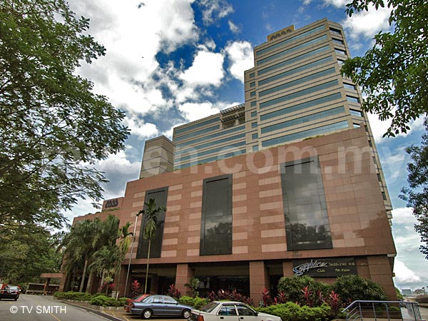
Address: 12 Jalan Dewan Bahasa, Kuala Lumpur, Malaysia
Postcode (Poskod): 50460 Kuala Lumpur
Tel: +603 2146 8000
Fax: +603 2142 3863
Website: http://www.maa.com.my/
Area: Wilayah Persekutuan Kuala Lumpur, Federal Territory of Kuala Lumpur (KL / WP)
Jurisdiction: Dewan Bandaraya Kuala Lumpur DBKL - KL City Hall (See Local Govt / KL Map)
Directions: From the Loke Yew intersection (formerly Bulatan Edinburgh), take the road where Dewan Bahasa & Pustaka is located.
Info / Insights: Tenants of Menara MAA include the Melewar Group companies, Cafe Capistrano, Charlie's Reserve, Sapphire Club and i-Zen Spa.
At first glance, one may wonder why someone would choose to construct a commercial property so close to the sprawling cemeteries. Given that Malaysians are a superstitious lot, wouldn't the location be an unattractive proposition? There is a worthy and paradoxical reason, it seems. The owners are public-listed Malaysian Assurance Alliance Berhad, which owns MAA Assurance, one of the country’s leading insurance companies. What better way to remind visitors of the importance of life insurance -- in protecting living dependents against the financial loss of death -- than the sober sight of a tombstone? :)
The vast tract of burial land (including the Gong Dong Yi San Chinese cemetery and a Christian graveyard) is currently locked in a re-development standstill due to political expediency. If the surrounding graves are ever relocated, Menara MAA will find itself positioned at KL's largest (and last) parcel of prime and strategic land.
Nearby Landmarks: Tupai Tupai (A), Dewan Bahasa Dan Pustaka (B), Menara DBP (C)
Surroundings: Bukit Petaling, Jalan Maharajalela (Birch Road), Jalan Istana, Kampung Attap, Jalan Hang Tuah (Shaw Road), Jalan Hang Jebat (Davidson Road), Jalan Bellamy, Jalan Kerayong, Jalan Syed Putra (Lornie Road), Jalan Loke Yew, Jalan Talalla, Jalan Hose, Jalan Choo Cheng Kay, Jalan San Peng (T), Jalan Wisma Putra, Institut Diplomasi dan Perhubungan Luar Negeri - Institute of Diplomacy & Foreign Relations - IDFR (D), Wisma Mirama (E), Cafe Cafe Restaurant (F), Merdeka View Apartment (G), Choo Cheng Khay Apartment (H), Ibu Pejabat Jabatan Bomba & Penyelamat Kuala Lumpur (I), Menara Belfield Condo (J), Istana Negara - National Palace (M), Alice Smith International School (N), Bellamy Road School (O), United Nations High Commission for Refugees - UNHCR (P), Loke Yew Flats (Q), Tsun Jin Chinese School (S), Gong Dong Yi San Chinese Burial Grounds (Cemetery) (X)
(use zoom and navigation buttons on top left of map to explore)
Nearby Hotels: Mirama Hotel (L), Mandarin Court Hotel (K) (see Hotel Listings)
Nearest Train Station: Maharajalela LRT Station (1.2 km by taxi)
Nearest Police Station: Balai Polis Tun HS Lee, Tel: 03 2070 2222
Nearest Fire Station: Balai Bomba & Penyelamat Jalan Hang Tuah, Tel: 03 9221 7222
Bus Number:
Distance: 2.8 km from Dataran Merdeka, 2.3 km from Sg Wang Plaza, 4.5 km to Mid Valley
GPS Coordinates: N3 07.868 E101 42.260
Position on Google Earth: View MyCen Location (what's this?)
Main Map: Mycen Map Of Kuala Lumpur City Center
Featured Category : Insurance
Related Categories: Transport | Hotels | Taxis | Bereavement | Feng Shui
Connecting Maps: Chinese Assembly Hall, Kg Attap | Thean Hou Temple, Jalan Syed Putra
KL Sentral Brickfields | Chinatown | Fraser Business Park, Sg Besi |
|
|
| Find Other Places: Directions & Map Index | Search For A Location | More Maps Here |
Please help us refine the location information by sending additional info, suggestions, updates, comments to tvsmith@mycen.com.my
Maps powered by Google Maps unless otherwise stated. Additional geographical information, overlays, placemarks, waypoints, data, pictures and design created & owned by Malaysia Central & TV Smith. All rights reserved. No warranty on validity, completeness or accuracy given or implied. Use at your own risk. Property names, place names, location mark, point-of-interest, business names, designs, signs, graphics, symbols, icons, brands & logos are trademarks of their respective owners. |
| queries: photo, pics, image, gis, place, places, attraction, guide, streetmap, roadmap, building, site, streets, directory, roads, public transport, travel, get, go, going, getting, drive, driving, walk, direction, journey, lrt, ktm, cab, whereabouts, locate, about, how to go, where is, far, near, shortest, find, miles, from, lokasi, gambar, tempat, cari, cara, macam mana, di mana, bagaimana, pergi, ke, jalan, bangunan, wisma, teksi, peta, panduan, arahan, arah memandu, pandu, alamat, tapak, berdekatan, perjalanan, dari, laluan |
|
|
|
|