|
MyCen Directions: Thean Hou Temple, Kuala Lumpur
|
Driving guide & ground directions with road maps, street pictures & information of the route, location or area
|
| Find Other Places: Directions & Map Index | Search For A Location | More Maps Here |
|
|
 MyCen Directions
Updated & Current
Clear & Accurate Maps
With Latest Landmarks
GPS Verified On Ground
Portal-Wide Useful Links
Picture Of Every Location
Comprehensive Information
Made With Local Knowledge
Each Place Visited In Person
Satellite & Google Earth View
Independent Opinion & Review

As Seen On TV's

|
|
|
|
|
|
|
|
|
|
| View the Full MyCen Events Calendar here |
|
Address: 65 Persiaran Endah, off Jalan Syed Putra, Kuala Lumpur, Malaysia
Postcode (Poskod): 50460 Kuala Lumpur
Tel: +603 2274 7088
Fax: +603 2260 1623
Website: http://www.hainannet.com.my/
Area: Wilayah Persekutuan Kuala Lumpur, Federal Territory of Kuala Lumpur (KL / WP)
Jurisdiction: Dewan Bandaraya Kuala Lumpur DBKL - KL City Hall (See Local Govt)
Events At This Location: See MyCen Events Calendar
Directions: From the direction of Istana Negara, slow down after passing Kuen Cheng School on your left. Keep to the extreme left and enter the slip road (Jalan Robson) which runs parallel to Jalan Syed Putra. The road sign shows exit to Brickfields.
The first turning on your left is Lorong Syed Putra Kiri which takes you to the shabby Le Chateau condos, the new Kuen Cheng School (2) and a sprawling cemetery. Do not turn here but drive up further and you will soon see Wisma Belia (Hostel) and Bangunan MCOBA (UEM) on your left. The next turning is Persiaran Endah which takes you up to the temple. You can also approach from the direction of the Brickfields as Jalan Robson is a two-way street.
The Thean Hou Temple is situated on the top of Robson Hill. Though not very high, the initial ascent is quite steep. Make sure your clutch is not slipping or your engine can handle traffic jams on a slope. Parking is adequate but is not free on weekends and during festivals.
During the Chinese New Year, there is free half-hourly shuttle bus service from Hotel Midah in Kg Attap and KL Sentral.
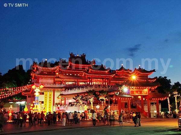
Info / Insights: Opened in 1989, the picturesque Thean Hou Temple has become a pilgrimage site of sorts for Taoists during Chinese New Year, the Lantern Festival and on wedding days. It is more than a place of worship and has grown into a popular tourist destination. The temple design incorporates ancient Chinese architecture with carved decorative beams, protruding roofs, intricate eaves, pagodas and murals.
The Thean Hou Temple is is one of the largest Chinese temples in South-East Asia. The building has four levels, including a marriage registration office on the basement. In the prayer hall, the shrine of the Thean Hou Goddess sits between the Goddess of the Waterfront (Swei Mei Goddess) and the Goddess of Mercy (Kuan Yin).
Like most Chinese temples, there are souvenir stores and eateries within its premises. The Thean Hou Temple is built and operated by the Selangor and Federal Territory Hainan Association (Persatuan Hainan Selangor & Wilayah Persekutuan) which has a history of some 115 years in Malaya / Malaysia.
Jalan Syed Putra (formerly Lornie Road) is often mistakenly referred to as Jalan Klang Lama (Old Klang Road). Spelling variations: Thian How Gong, Thien Hou Kong, Tean Hou, Tian Hau, Tien Hou Mew, Thin How Kung
See also: Dong Zen Temple, Jenjarom | Buddhist Maha Vihara Temple, Brickfields
Additional Pics: Sightings: Lantern Festival at Thean Hou Temple 2007
Sightings: Chinese New Year at Thean Hou Temple 2008
Nearby Landmarks: Robson Heights Condo (1), Impian Diatas (2), Kristal Court (3)
Surrounding Places: Bangunan MCOBA - UEM (4), Wisma Belia & Kompleks MAYC (E), Pusat Latihan KEMAS - PLK Kuala Lumpur, Jabatan Kemajuan Masyarakat (6),
Kuen Cheng Chinese Girls School (7), Istana Negara - National Palace (8), UNHCR - United Nations High Comission For Refugees (9), Alice Smith School Jalan Bellamy (10), Jalan Kerayong Chinese Cemetery (Gong Dong Yi San) (11), Kuen Cheng Chinese Primary School 2 (12), Le Chataeu II Condo (13), Le Chataeu Condo (14), KL Sentral Station (15), Buddhist Maha Vihara Temple, Brickfields (16), Tun Sambanthan Monorail LRT Station (17), Bangsar Putra LRT Station (18), MidValley KTM Komuter Station (19), Mid Valley City - MidValley Megamall, The Gardens, Northpoint, Centrepoint, Boulevard Hotel, Menara IGB, Cititel (20), Menara MAA (21), Restoran Tupai Tupai (22), Ibu Pejabat Polis Daerah Brickfields - moved here (23), Balai Polis Travers (24), Muzium Negara - National Museum (25), KL Sentral Monorail LRT Station (26), Sri Bukit Persekutuan Gated Bungalows & Townhouses (27)
(use zoom and navigation buttons on top left of map to explore)
Surrounding Roads: Persiaran Endah, Jalan Syed Putra, Jalan Robson, Jalan Tun Sambanthan, Jalan Sultan Abdul Samad, Jalan Bangsar, Jalan Istana, Jalan Kerayong, Jalan Bellamy, Jalan Dewan Bahasa, Taman Seputeh, Bukit Petaling, Bukit Persekutuan (Federal Hills)
Nearby Hotels: Wisma Belia (E), YMCA, Korea Hotel, Ritz Garden Hotel KL, KL Hilton, Le Meridian, Cititel Mid Valley, Boulevard Hotel, Heritage Station Hotel (Old Railway Station)
(For telephone contact, full address & web site of each hotel, see our Hotel Listings)
Nearest Train Station: Tun Sambanthan LRT Station (across river by overhead pedestrian bridge) (17), MidValley KTM Komuter Station (19) (2 km by taxi)
Nearest Police Station: Balai Polis Brickfields
Nearest Fire Station: Balai Bomba & Penyelamat Klang Lama, Tel: 03 7984 8753
Bus Number:
Distance: 6.4 km to Amcorp Mall, PJ, 5.5 km from Sungei Wang Plaza (Bukit Bintang)
GPS Coordinates & Position: N3 07.311 E101 41.266
Featured Category : Religion
Related Categories: Places Of Attraction | Buddhism | Tourism | Matrimony | Events
Connecting Maps: Wisma Belia | KL Sentral | Brickfields Buddhist Temple | YMCA |
|
|
| Find Other Places: Directions & Map Index | Search For A Location | More Maps Here |
Please help us refine the location information by sending additional info, suggestions, updates, comments to tvsmith@mycen.com.my
Maps powered by Google Maps unless otherwise stated. Additional geographical information, overlays, placemarks, waypoints, data, pictures and design created & owned by Malaysia Central & TV Smith. All rights reserved. No warranty on validity, completeness or accuracy given or implied. Use at your own risk. Property names, place names, location mark, point-of-interest, business names, designs, signs, graphics, symbols, icons, brands & logos are trademarks of their respective owners. |
| queries: photo, pics, image, gis, place, places, attraction, guide, streetmap, roadmap, building, site, streets, directory, roads, public transport, travel, get, go, going, getting, drive, driving, walk, direction, journey, lrt, ktm, cab, whereabouts, locate, about, how to go, where is, far, near, shortest, find, miles, from, lokasi, gambar, tempat, cari, cara, macam mana, di mana, bagaimana, pergi, ke, jalan, bangunan, wisma, teksi, peta, panduan, arahan, arah memandu, pandu, alamat, tapak, berdekatan, perjalanan, dari, laluan |
|
|
|
|