|
MyCen Directions: Platinum Hill Condominium, Taman Melati Utama
|
Driving guide & ground directions with road maps, street pictures & information of the route, location or area
|
| Find Other Places: Directions & Map Index | Search For A Location | More Maps Here |
|
|
 MyCen Directions
Updated & Current
Clear & Accurate Maps
With Latest Landmarks
GPS Verified On Ground
Portal-Wide Useful Links
Picture Of Every Location
Comprehensive Information
Made With Local Knowledge
Each Place Visited In Person
Satellite & Google Earth View
Independent Opinion & Review

As Seen On TV's

|
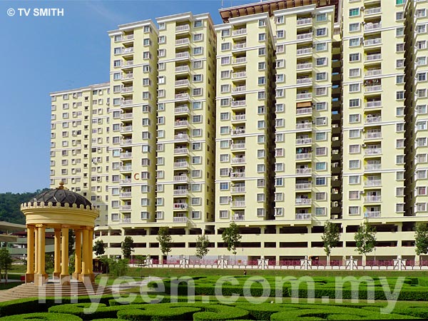
PV3, PV5, PV6 & PV8 Condos, Taman Melati Utama, Gombak
|
|
|
|
|
|
|
|
|
| View the Full MyCen Events Calendar here |
|
Address: Taman Melati Utama, Gombak, Kuala Lumpur, Malaysia
Postcode (Poskod): 53100 Kuala Lumpur
Developer: Platinum Victory Development Sdn Bhd
Tel: 03 4108 8666
Fax: 03 4108 8333
Website: http://www.platinumvictory.com/
Area: Wilayah Persekutuan Kuala Lumpur, Federal Territory of Kuala Lumpur (KL / WP)
Jurisdiction: Dewan Bandaraya Kuala Lumpur DBKL - KL City Hall (See Local Govt / KL Map)
Directions: On the MRR2 (Genting Highlands-bound) from Taman Melawati, keep left after the Setapak split-off. Travel another 900 metres and turn left just before the Esso Station.
Info / Insights: The 32-acre Platinum Hill development project in Taman Melati Utama consists of several blocks of condominiums (PV3, PV5, PV6 & PV8), a row of shop offices that flank the MRR2 and a business park.
Platinum Victory is also developing the Setapak Lake City project in Danau Kota.
Nearby Landmarks: PV 6 Condo (A), PV 5 Condo (B), PV 3 Condo (C)
Surroundings Places: Petronas & McDonald's (F), Platinum Park (G), Kenari Apartments (H), Balai Bomba & Penyelamat Wangsa Maju (I), Putra Villa Condo (J), Cemerlang Heights (K), Cemerlang Apartment (L), Masjid Salehuddin Al-Ayyubi (M), Sri Tioman 1 Apartment (N), Sri Tioman 2 Apartment (O), Kuarters Institusi Pendidikan Taman Melati - Pangsapuri Desa 17 (Q), Dewan Serbaguna Taman Melati (R), Melati Impian Apartment (S), Kompleks Beliawanis Gombak (T), Pasar Tani Gombak Setia (U), Pusat Komunit Gombak & Klinik 1Malaysia Taman Melati (V), Kompleks Belia Gombak - Asrama Lelaki Aspura (W), Kolej Tunku Abdul Rahman KTAR/TARC - TAR College Campus (X)
(use zoom and navigation buttons on top left of map to explore)
Surroundings Roads: Jalan Lingkaran Tengah 2 - Middle Ring Road 2 (MRR 2), Jalan Melati Utama 4, Jalan Taman Melati 1, Jalan Gombak, Jalan Taman Ibukota, Jalan Taman Putra, Jalan Kolam Air, Ulu Klang
Nearby Hotels: (see Hotel Listings)
Nearest Train Station: Taman Melati LRT Station, Terminal Putra LRT Station
Nearest Police Station: Balai Polis Taman Melati (P), Tel: 03 4107 9073
Nearest Fire Station: Balai Bomba & Penyelamat Wangsa Maju, Tel: 03 4108 5729
Bus Number:
GPS Coordinates: N3 13.369 E101 43.792
Position on Google Earth:
Featured Category : Properties
Related Categories: Real Estate Agents
Connecting Maps: Platinum Walk Danau Kota | Steven's Corner Jalan Genting Kelang
Ong Tai Kim Plaza Idaman Gombak | Giant Hypermarket Batu Caves
Pasar Taman Sri Gombak | K Club, Taman Melawati | UIA Gombak |
|
|
| Find Other Places: Directions & Map Index | Search For A Location | More Maps Here |
Please help us refine the location information by sending additional info, suggestions, updates, comments to tvsmith@mycen.com.my
Maps powered by Google Maps unless otherwise stated. Additional geographical information, overlays, placemarks, waypoints, data, pictures and design created & owned by Malaysia Central & TV Smith. All rights reserved. No warranty on validity, completeness or accuracy given or implied. Use at your own risk. Property names, place names, location mark, point-of-interest, business names, designs, signs, graphics, symbols, icons, brands & logos are trademarks of their respective owners. |
| queries: photo, pics, image, gis, place, places, attraction, guide, streetmap, roadmap, building, site, streets, directory, roads, public transport, travel, get, go, going, getting, drive, driving, walk, direction, journey, lrt, ktm, cab, whereabouts, locate, about, how to go, where is, far, near, shortest, find, miles, from, lokasi, gambar, tempat, cari, cara, macam mana, di mana, bagaimana, pergi, ke, jalan, bangunan, wisma, teksi, peta, panduan, arahan, arah memandu, pandu, alamat, tapak, berdekatan, perjalanan, dari, laluan |
|
|
|
|