|
MyCen Directions: International Islamic University Malaysia - IIUM
|
Driving guide & ground directions with road maps, street pictures & information of the route, location or area
|
| Find Other Places: Directions & Map Index | Search For A Location | More Maps Here |
|
|
 MyCen Directions
Updated & Current
Clear & Accurate Maps
With Latest Landmarks
GPS Verified On Ground
Portal-Wide Useful Links
Picture Of Every Location
Comprehensive Information
Made With Local Knowledge
Each Place Visited In Person
Satellite & Google Earth View
Independent Opinion & Review

As Seen On TV's

|
Universiti Islam Antarabangsa Malaysia - UIA Gombak
|
|
|
|
If interactive map above is slow to load or not showing, CLICK HERE for static view
|
|
|
|
|
| View the Full MyCen Events Calendar here |
|
Address: Jalan Sungai Pusu, Gombak, Selangor, Malaysia
Postcode (Poskod): 53100 Gombak
Post Office Box: P.O. Box 10, 50728 Kuala Lumpur
Tel: +603 6196 4000
Fax: +603 6196 4160
Website: http://www.iiu.edu.my/
Area: Selayang, Selangor (Sel / D.E.)
Jurisdiction: Majlis Perbandaran Selayang - MPS (See Local Govt)
Directions: From Jalan Gombak, go over the flyover at the Greenwood Park junction and drive through rustic scenery until you reach a T-junction. Turn right at the traffic lights into Jalan Sg Pusu. Alternatively, use the MRR 2 from either Selayang or Ampang to get to Karak Highway. Just before the the Gombak toll plaza, enter the slip road on the extreme left. Turn right when you reach a traffic light T-junction.
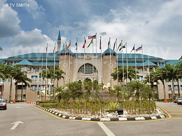
Info / Insights: The International Islamic University Malaysia (IIUM) claims to be the only Islamic university that uses English as its medium of instruction. This is not surprising as the university enrolled 18,000 undergraduate and postgraduate students from over 90 countries in 2007. Founded in 1983, the bachelor degree tuition fees for international students range from about RM 7,000 (Human Sciences) to RM 39,000 (Medicine) per academic year.
The 700-acres Gombak (or Kuala Lumpur) campus sits on the foothill of the beautiful Klang Gates Quartz Ridge. Universiti Islam Antarabangsa (UIA or UIAM) has a Kuantan branch campus which is bigger in land size. In addition, there's the smaller Petaling Jaya Campus and the The International Institute of Islamic Thought and Civilization (ISTAC) faculty in Jalan Duta, KL.
Additional Pics: Sightings: Founder Tun Dr Mahathir's Keynote Address at IIUM
Sightings: Rain Clouds Over Gombak Mosque
Nearby Landmarks: Karak Highway Gombak Toll Plaza, UniKL BMI (Universiti Kuala Lumpur British Malaysian Institute), International Islamic School (IIS), Kuarters Institusi Pendidikan - Batu 8 Sg Pusu, Sekolah Berasrama Penuh Integrasi Gombak (SBP)
Surroundings: Jalan Sungei Pusu, Karak Highway, Jalan Gombak, UniKL BMI (Universiti Kuala Lumpur British Malaysian Institute),Terminal Putra LRT Station, Taman Melati LRT Station, Middle Ring Road 2 (MRR2), Jalan Taman Harmonis, Taman Greenwood, Sri Gombak, Batu Caves, Selayang, DUKE, Klang Gates Dam, Karak Highway, Road to Genting Highlands
(use zoom and navigation buttons on top left of map to explore)
Nearby Hotels: Selayang Hotel (see Hotel Listings)
Nearest Train Station: Terminal PUTRA LRT Station (5.2 KM by taxi or feeder bus)
Nearest Police Station: Balai Polis Gombak, Tel: 03 6189 5222
Bus Number: RapidKL Bas T201, T203, T231
Distance: 13.7 km to Eye Of Malaysia Ferris Wheel, Taman Tasik Titiwangsa via Jalan Pahang
6.6 km to Batu Caves via MRR 2
13.9 km to Ampang Puteri Specialist Hospital, Ampang Point via MRR 2
18 km to Low Yat Plaza, Bukit Bintang via Sentul / Chow Kit / Jalan Sultan Ismail
27.7 km to Digital Mall, Sec 14, PJ via Selayang / LDP (Lebuhraya Damansara-Puchong)
GPS Coordinates: Latitude: 3°15'5.02"N Longtitude: 101°44'5.72"E
Position on Google Earth: View MyCen Location (what's this?)
Main Maps: Mycen Map Of Klang Valley North East | Selayang | Kuala Lumpur City North
Featured Category : Public Universities
Related Categories: Islam | Private Colleges | Transport | Education | Foreign Embassies
Connecting Maps: Giant Hypermarket Batu Caves | Pasar Taman Sri Gombak | Batu Caves
Platinum Hill, Taman Melati Utama | Genting Hotel, Genting Highlands |
|
|
| Find Other Places: Directions & Map Index | Search For A Location | More Maps Here |
Please help us refine the location information by sending additional info, suggestions, updates, comments to tvsmith@mycen.com.my
Maps powered by Google Maps unless otherwise stated. Additional geographical information, overlays, placemarks, waypoints, data, pictures and design created & owned by Malaysia Central & TV Smith. All rights reserved. No warranty on validity, completeness or accuracy given or implied. Use at your own risk. Property names, place names, location mark, point-of-interest, business names, designs, signs, graphics, symbols, icons, brands & logos are trademarks of their respective owners. |
| queries: photo, pics, image, gis, place, places, attraction, guide, streetmap, roadmap, building, site, streets, directory, roads, public transport, travel, get, go, going, getting, drive, driving, walk, direction, journey, lrt, ktm, cab, whereabouts, locate, about, how to go, where is, far, near, shortest, find, miles, from, lokasi, gambar, tempat, cari, cara, macam mana, di mana, bagaimana, pergi, ke, jalan, bangunan, wisma, teksi, peta, panduan, arahan, arah memandu, pandu, alamat, tapak, berdekatan, perjalanan, dari, laluan |
|
|
|
|