|
MyCen Directions: Ampang Puteri Specialist Hospital
|
Driving guide & ground directions with road maps, street pictures & information of the route, location or area
|
| Find Other Places: Directions & Map Index | Search For A Location | More Maps Here |
|
|
 MyCen Directions
Updated & Current
Clear & Accurate Maps
With Latest Landmarks
GPS Verified On Ground
Portal-Wide Useful Links
Picture Of Every Location
Comprehensive Information
Made With Local Knowledge
Each Place Visited In Person
Satellite & Google Earth View
Independent Opinion & Review

As Seen On TV's

|
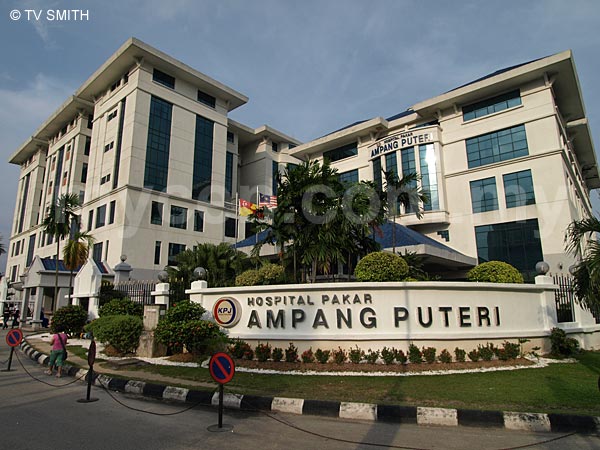
Hospital Pakar Ampang Puteri
|
|
|
|
|
|
|
|
|
| View the Full MyCen Events Calendar here |
|
Address: 1 Jalan Mamanda 9, Taman Dato' Ahmad Razali, Ampang, Selangor, Malaysia
Postcode (Poskod): 68000 Ampang
Tel: +603 4270 2500 (General), +603 4270 7060 (Emergency)
Fax: +603 4270 2443
Website: http://www.apsh.kpjhealth.com.my/
Area: Selangor Darul Ehsan (SEL D.E.)
Jurisdiction: Majlis Perbandaran Ampang Jaya - MPAJ (See Local Govt)
Directions: From Ulu Kelang, turn left after the Ampang Jaya exit where the Mobil station is. From KL, after the Ampang/MRR2 flyover, you will see the Ampang Point Shopping Centre on your left. Turn left at the traffic junction where the De Palma Hotel is. Head till the end of the road and turn left at the T Junction. You can also use the Elevated Highway but you need to make a U-turn in Ampang Jaya or at the end of the highway..
Info: Part of the KPJ Healthcare Group, the specialist medical center is also known as APSH and sometimes spelled as Ampang Putri.
Nearby Landmarks: Ampang Point Shopping Centre (A), Hotel De Palma (B), Kompleks Sukan SunSuria (formerly Sports Planet) (C)
Surroundings: Little Korea (D), Elevated Highway Ampang Exit (E), Mutiara International Grammar School (F), ISKL - International School Of KL (G), MARDEC (H), SPCA (I), Plaza Ampang City (K), GCB Court Condo (L), Bangunan RISDA (M), Kojaya Apartments (N), Flamingo Institute (O), Restoran Suzi's Corner (P), Petronas Station with McDonald's, MaxValu, Imbiss German Deli and Original Kayu Nasi Kandar (Q), Mobil Station (R), Tiara Ampang Condo (S), 1 Ampang Avenue Condo (T), Ampang Impiana Condo (U), Palm Inn Ampang Point Hotel (above Restoran Nasi Kandar Pelita)
(use zoom and navigation buttons on top left of map to explore)
Surrounding Roads: AKLEH, Jalan Ampang, Middle Ring Road 2 - MRR2 (Jalan Lingkaran Tengah 2), Jalan Ampang Putra, Jalan Kerja Ayer Lama, Jalan Mamanda
Nearby Hotels: De Palma Hotel (B), Flamingo Hotel (J), Palm Inn (V) (see Hotel Listings)
Nearest Train Station: Ampang LRT Station (1.5 km by taxi & feeder bus)
Nearest Police Station: Balai Polis Ampang, Tel: 03 4252 2222
Bus Number:
Distance: 4.6 km from KLCC via Jalan Ampang
GPS Coordinates: N3 09.602 E101 45.093
Position on Google Earth: View MyCen Location (what's this?).
Main Map: Mycen Map Of KL City East - Ampang
Featured Category : Private Hospitals
Related Categories: Government Hospitals | Dentists | Clinics | Health | Florists | Insurance
Connecting Maps: Galaxy Ampang | SPCA Selangor | Plaza Ampang City, Jalan Ampang
Hospital Ampang, Pandan Mewah | Gleneagles Intan Medical Centre
Ampang-KL Elevated Highway | Nine Emperor Gods Temple | DUKE |
|
|
| Find Other Places: Directions & Map Index | Search For A Location | More Maps Here |
Please help us refine the location information by sending additional info, suggestions, updates, comments to tvsmith@mycen.com.my
Maps powered by Google Maps unless otherwise stated. Additional geographical information, overlays, placemarks, waypoints, data, pictures and design created & owned by Malaysia Central & TV Smith. All rights reserved. No warranty on validity, completeness or accuracy given or implied. Use at your own risk. Property names, place names, location mark, point-of-interest, business names, designs, signs, graphics, symbols, icons, brands & logos are trademarks of their respective owners. |
| queries: photo, pics, image, gis, place, places, attraction, guide, streetmap, roadmap, building, site, streets, directory, roads, public transport, travel, get, go, going, getting, drive, driving, walk, direction, journey, lrt, ktm, cab, whereabouts, locate, about, how to go, where is, far, near, shortest, find, miles, from, lokasi, gambar, tempat, cari, cara, macam mana, di mana, bagaimana, pergi, ke, jalan, bangunan, wisma, teksi, peta, panduan, arahan, arah memandu, pandu, alamat, tapak, berdekatan, perjalanan, dari, laluan |
|
|
|
|