|
MyCen Directions: South Klang Valley Expressway - SKVE
|
Driving guide & ground directions with road maps, street pictures & information of the route, location or area
|
| Find Other Places: Directions & Map Index | Search For A Location | More Maps Here |
|
|
 MyCen Directions
Updated & Current
Clear & Accurate Maps
With Latest Landmarks
GPS Verified On Ground
Portal-Wide Useful Links
Picture Of Every Location
Comprehensive Information
Made With Local Knowledge
Each Place Visited In Person
Satellite & Google Earth View
Independent Opinion & Review

As Seen On TV's

|
Lebuhraya Lembah Klang Selatan or S.K.V.E.
|
|
|
|
|
|
|
|
|
| View the Full MyCen Events Calendar here |
|
Concession Holder: SKVE Holdings Sdn Bhd
Office Address: Block B, Unit 3A01, Phileo Damansara 1, Petaling Jaya, Selangor, Malaysia
Postcode (Poskod): 46350 Petaling Jaya
Emergency Helpline / Careline: 1 300 88 0026
Tel: +603 7960 7010
Fax: +603 7960 7013
Website: http://www.skveholdings.com/
Area: Selangor Darul Ehsan (SEL D.E.)
Jurisdiction: Lembaga Lebuhraya Malaysia - LLM (Malaysian Highway Authority)
Directions: From Kajang, head towards Putrajaya / Serdang/ UPM via SILK. The SKVE expressway begins where SILK ends near the UNITEN campus.
Info / Insights: When fully completed, the new SKVE (South Klang Valley Expressway) will eventually link Kajang/ Bangi to Pulau Indah (Westport) and Pulau Carey. In between, it also connects users to Putrajaya / Cyberjaya and Sepang Airport via the Central Link. See updated map, video and info at the New MyCen SKVE Page.
The expressway currently ends at Puchong, when traveling from Kajang.
For westbound vehicles, enter at the Ayer Hitam Toll Plaza just after MAEPS and Uniten. On the other end, exit at the Saujana Putra Toll Plaza.
The approximately 12 km stretch should take about 10 minutes. The highway also serves as an alternative route to the congested LDP (Lebuhraya Damansara-Puchong).
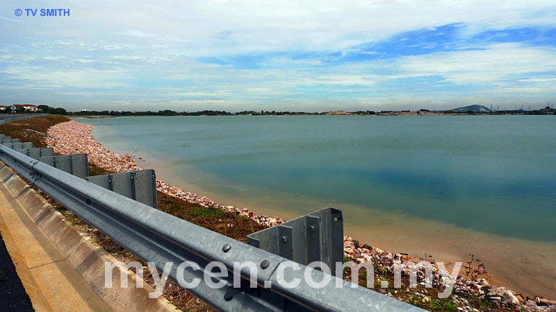
For many travelers it may be their first opportunity to marvel at the many gigantic 'lakes' dotting the Puchong landscape. At one part, it feels as though one is driving along a coastal road. The so-called lakes are actually former (excavated) tin mines from an industry that once propelled the Malaysian economy. Today, their epitaphial scars -- in the form of watery graves -- stand eerily in many parts of Klang (and Kinta) Valley.
Addendum: You might be astonished to see another toll gate (of the same name), a few meters after exiting SKVE at Saujana Putra. The plaza is for entering/exiting the North-South Expressway Central Link NSECL (Lebuhraya Utara-Selatan Hubungan Tengah) or ELITE Highway (E6) to KLIA/Nilai or NKVE. There is an alternative access to the left of the roundabout.
Toll:
Nearby Landmarks: SKVE Saujana Putra Toll Plaza (1), SKVE Ayer Hitam Toll Plaza (2), 'Great Lakes' Area (3)
Surrounding Places: Desaria Villa Condos (5), Taman Suria Tropika (6), Stesen Janaelektrik Putrajaya (formerly Serdang Power Station) (7), MAEPS Gate 2 (8)
ELITE Highway Saujana Putra Toll Plaza (20), Petronas Station (30), Maju Expressway (50)
(use zoom and navigation buttons on top left of map to explore)
Surrounding Roads: SILK - Sistem Lingkaran-Lebuhraya Kajang, MEX - Maju Expressway (50),
NSE - North-South Expressway, ELITE Highway, LEKAS Highway
Nearby Hotels: Palm Garden Hotel, Marriott Putrajaya, IOI Resort, Uniten Residence Hotel
(For telephone contact, full address & web site of individual hotel, see our Hotel Listings)
Nearest Train Station: Serdang KTM Station, Putrajaya Sentral - ERL (KLIA Express Transit) Station
Nearby Police Station:
Bus Number:
Distance:
GPS Coordinates & Position: N2 58.594 E101 39.100 (Ayer Hitam Toll Plaza)
N2 56.884 E101 34.917 (Saujana Putra Toll Plaza)
Featured Category : Expressways
Related Categories: Motoring | Ambulance | Workshops | Aviation | Transport | Taxis
Connecting Maps: Malaysia Agro Exposition Park Serdang - MAEPS | Serdang Hospital
Residence Hotel, Uniten Bangi | Nasi Beriani Gam Putrajaya | Kajang Town
Lebuhraya Kajang-Seremban - LEKAS |
|
|
| Find Other Places: Directions & Map Index | Search For A Location | More Maps Here |
Please help us refine the location information by sending additional info, suggestions, updates, comments to tvsmith@mycen.com.my
Maps powered by Google Maps unless otherwise stated. Additional geographical information, overlays, placemarks, waypoints, data, pictures and design created & owned by Malaysia Central & TV Smith. All rights reserved. No warranty on validity, completeness or accuracy given or implied. Use at your own risk. Property names, place names, location mark, point-of-interest, business names, designs, signs, graphics, symbols, icons, brands & logos are trademarks of their respective owners. |
| queries: photo, pics, image, gis, place, places, attraction, guide, streetmap, roadmap, building, site, streets, directory, roads, public transport, travel, get, go, going, getting, drive, driving, walk, direction, journey, lrt, ktm, cab, whereabouts, locate, about, how to go, where is, far, near, shortest, find, miles, from, lokasi, gambar, tempat, cari, cara, macam mana, di mana, bagaimana, pergi, ke, jalan, bangunan, wisma, teksi, peta, panduan, arahan, arah memandu, pandu, alamat, tapak, berdekatan, perjalanan, dari, laluan |
|
|
|
|